Return to Beaker burials of Thanet -
Part 1
Display Contents
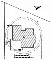
Beauforts, North Foreland Avenue, Broadstairs (BNF04)
Introduction
Site description
Stratigraphy
The central grave
The coffin-structure
The central burial
Radiocarbon-date
The backfills
The roundbarrow ditch
Post-barrow activity
Other Beaker activity
Other roundbarrows
Specialist reports:
The skeleton
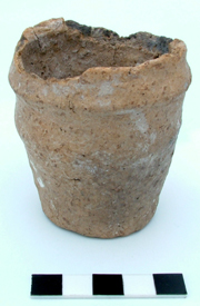
The Beaker
The flint
Introduction
In October/November 2004 an
Archaeological Watching
Brief on groundworks associated with the
foundations for an underground garage at a house known as ‘Beauforts’
in North Foreland Avenue, Broadstairs, revealed part of the circuit of
a ring-ditch of a roundbarrow and a
rectangular central grave. The grave contained a Beaker burial laid
within a
(now decayed) wooden coffin-structure.
Artefact scales in centimetre divisions
Feature scales in 0.5 metre divisions
The site was located on a
south-east facing slope, approximately 200m
westwards of the present cliff-line. The underlying natural geology was
a deposit of Upper Chalk and the archaeological features were cut into
the
surface of this chalk at 33.27 to 33.74m AOD (the height 'Above
Ordnance Datum').
The slope on which the site
rests descends
from a plateau to the north-west (at approximately 40m AOD) which forms
the roughly north/south running spine of the North Foreland Hill
promontory. This hill comprises the eastern side of a broad valley
which runs down to the sea in the area of Joss Gap.
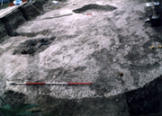
The ledge
There was no direct stratigraphic
relationships
between the central grave and the surrounding ring-ditch; (in other
words the two features and the deposits which comprised their infills
were spatially separate and did not inter-cut or interact with each
other).
This means that it is not certain
whether the grave or the ring-ditch was constructed first. However
convention would suggest that the grave was dug first and the
ring-ditch was excavated around it to provide material for a central
mound which covered the burial.
The features are discussed below,
ordered on this basis.
Top
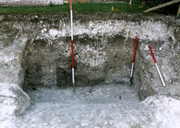
The central grave
The central grave
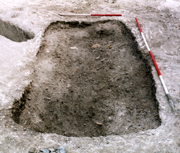
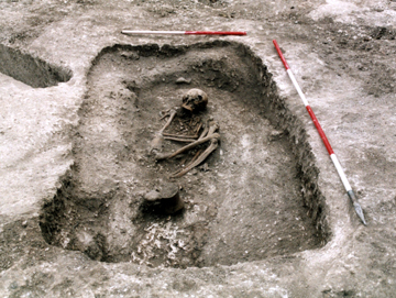
The grave was rectangular
and well-cut, 2.28m long by a maximum of
1.30m wide and with a flattish base cut up to 0.36m below the surface
of the chalk. A small ledge was present in the north-west corner.
The grave was orientated east north-east/west south-west through the long axis and contained a crouched inhumation burial; (the skeletal remains of a human laid in a foetal position - typical of Prehistoric inhumation burials). The body had been laid to rest within a coffin-structure and was accompanied by a Beaker vessel.
The grave was orientated east north-east/west south-west through the long axis and contained a crouched inhumation burial; (the skeletal remains of a human laid in a foetal position - typical of Prehistoric inhumation burials). The body had been laid to rest within a coffin-structure and was accompanied by a Beaker vessel.
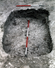
Note the soil mark of a likely coffin-structure
A soil mark visible in the
unexcavated grave fill suggested the
existence of a rectangular coffin-structure approximately 1.70m long by
0.81m wide.
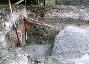
The excavation of the grave showed that in places chalk spoil had been backfilled around a steep-sided structure. This may have originally been vertically-sided (effectively a box, made either of wood or wicker-work perhaps) which latterly decayed and allowed the chalk backfill to take on a slumped profile.
The excavation of the grave showed that in places chalk spoil had been backfilled around a steep-sided structure. This may have originally been vertically-sided (effectively a box, made either of wood or wicker-work perhaps) which latterly decayed and allowed the chalk backfill to take on a slumped profile.
Alternatively the position
of a steeply
sloping bank of chalk which encompassed and partially underlay the back
of the skeleton might suggest that the coffin-structure could
originally have been
round-sided - perhaps a hollowed-out log (or similar shape in
wicker-work).
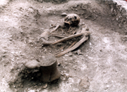
Note the chalk backfill which partly surrounded the body
The remains were those of a
woman,
probably in her 40’s, who had been
laid on her left-hand side with her head to the east end of the grave,
facing south. She had likely been buried within a rectangular wooden
coffin-structure, with a Beaker
positioned at her feet.
A possible additional
grave-good may have been
a rather utilitarian small end and side scraper recovered from inside
the skull
during post-excavation work, though this may have been just a
relatively contemporary discard.
Plenty of space remained at the western end of the grave beyond the Beaker and this area may have seen the deposition of perishable, organic grave-goods or tributes (such as flowers or carved wooden objects perhaps).
Plenty of space remained at the western end of the grave beyond the Beaker and this area may have seen the deposition of perishable, organic grave-goods or tributes (such as flowers or carved wooden objects perhaps).
A bone sample from the
skeleton of the central burial was radiocarbon-dated to
2290-2190 BC (64.3%) / 2350-2130 BC (94.4%); (Wk 18732).
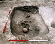
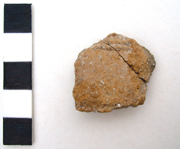
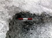
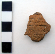
Sherd from another Beaker vessel found on the base of the grave underlying the primary chalk backfill
In places the grave was
first
backfilled around the coffin-structure with chalk spoil (the
'primary' backfill), likely gained from the initial excavation of the
grave. This fill was deepest around the northern side and eastern end
of the grave, where it extended to the surface of the Upper Chalk
natural.
Elsewhere only a shallow and intermittent deposit of chalk spoil was present around the coffin on the base of the grave and this had been covered by a secondary infill of soil. A single sherd from another comb-zoned Beaker vessel was discovered on the base of the grave (towards the south-easterly corner), underlying the primary backfill of chalk.
Elsewhere only a shallow and intermittent deposit of chalk spoil was present around the coffin on the base of the grave and this had been covered by a secondary infill of soil. A single sherd from another comb-zoned Beaker vessel was discovered on the base of the grave (towards the south-easterly corner), underlying the primary backfill of chalk.
No
chalk spoil had been
backfilled across the area of the body or directly above it. This may
well have been intentional. It is not known whether the
coffin-structure had a lid of some description, though if so it appears
that care was taken not to immediately cover the structure in chalk
spoil.
This may have been because
the chalk was generally being
saved to provide a gleaming-white, highly visible outer face to any
mound which may have covered the central burial. An alternative might
suggest the existence of a cultural or traditional taboo which
prevented the depositing
of chalk spoil on a burial. Few Prehistoric burials in general seem to
be covered by chalk spoil (those that have been discovered, anyway!).
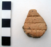
The first sherd from the Beaker to appear
Soil had infilled the area of the
coffin-structure, covering the body and the Beaker. One small rim sherd
from the Beaker was found slightly higher
up in the grave fill. This shows that there had been
some post-depositional movement within the grave. This is also
illustrated by the recovery of
two worked flints and a finger bone retrieved from inside the skull.
Residual Early Neolithic flint cores and blades were also found in the soil infill which covered the body.
Residual Early Neolithic flint cores and blades were also found in the soil infill which covered the body.
Only a small portion of the
ring-ditch was exposed on site, but as a whole the monument can
be estimated as being approximately 15.45m
in overall diameter. The ring-ditch
was sectioned (excavated) in two places. This revealed a variable but
steep-sided and truncated
(ie. cut-off) ‘V’ - shaped profile with a flat base.
The full width of the
ring-ditch
was not exposed with certainty, but can be estimated to be
approximately 1.41m. The
ditch base was cut 1.44m from the existing ground surface (a maximum of
0.68m below the level of the chalk). The base width varied from
0.40 to
at least 0.50m.
It looked like another archaeological section had been dug through the ditch some time previously!
Had the far side of the ditch been exposed and some archaeological work taken place when the house was built?
It looked that way, but was news to us!
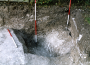
Note the back edge of another feature (a small pit or post-hole) which is just visible at the edge of the baulk to the right of the base of the second vertical scale
An old archaeological section visible in the baulk?
The ditch had a lower,
primary infill of pale-coloured soil containing
a moderate to profuse scatter of small and
medium-sized chalk fragments. The deposit likely derived from a mixture
of wind-blown
and rain-washed silts, deposited by wind and
water erosion of the surrounding groundsurface and through 'soil-creep'
on the down-slope. The chalk possibly derived from some of the excavated chalk spoil
and/or be the effects of weathering of the sides of the ditch. A
re-worked polished flint axe of likely Neolithic date was recovered
from the primary ditch fill.
Some slight biasing of the primary infill in places might indicate the former presence of an outer bank or other external spoil-source. However only two small sections could be excavated and this effect may more likely be the result of other, natural factors (such as the direction of the ground-slope and the prevailing wind).
Above the primary ditch fill was an upper, secondary infill comprising a different coloured deposit of soil, though it was otherwise of similar character.
A flint end-scraper typologically of Late Neolithic/Early Bronze Age or otherwise Beaker Period date was found in the secondary ditch fill, but could well be contemporary with the founding of the monument. It had probably lain on the groundsurface for some time before being incorporated (redeposited) into the part-infilled ditch.
The fills of the barrow ditch contained
a
distinct lack of evidence for significant activity in the periods
following the
construction of the barrow. This might be seen as somewhat surprising,
however it must be remembered that only a very small portion of the
barrow ditch was exposed and excavated.
No other features from later (or any other) periods could be certainly identified. The very back edge of what may have been a small pit or post-hole cut into the outer edge of the ring-ditch could just be seen (though the relationship was uncertain and it was otherwise inaccessible for investigation).
A substantial, multi-period Iron Age settlement is known to have existed on the top of North Foreland Hill just to the west (Boast, Gardner and Moody 2006). The lack of even the tiniest scrap of Iron Age pottery (a thing frequently encountered in the upper ditch fills of other barrows discovered at the St. Stephen's College site at North Foreland Hill) might suggest that the Beaker barrow ditch could have been in-filled (to the top of of the Upper Chalk at least) by this time.
It may also be that the Beaker barrow lay outside the boundaries of the Iron Age settlement. However an Archaeological Evaluation by the Trust for Thanet Archaeology on land immediately to the north-west of Beauforts at 16 North Foreland Road (NFA93; Perkins 1993) revealed five pits and post-holes, some of which held pot sherds thought of at the time as of possible Late Bronze Age or Early Iron Age date (800-300 BC).
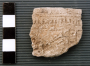
Beaker sherds from
St. Stephen's College (NFB99)
An Early Iron
Age burial was also discovered in the roundbarrow found immediately
opposite
the Beauforts site at Fairacre Lodge (Perkins 1981).
Other Beaker activity nearby
The only known evidence of specifically
Beaker-associated activity nearby comes from excavations at the site of
the former St. Stephen's College on North Foreland Hill nearby to the
west (NFB99; Boast, Gardner and Moody 2006).
This comprises two comb-decorated Beaker sherds from two different vessels, with another possibly plain Beaker sherd related to one of these existing pots. A fourth sherd from a fingernail-rusticated (ie. fingernail decorated) Beaker was discovered in the fill of the central burial of a large roundbarrow discovered on the site (more below). All the sherds are likely to be residual in their context (being redeposited during a later period).
This comprises two comb-decorated Beaker sherds from two different vessels, with another possibly plain Beaker sherd related to one of these existing pots. A fourth sherd from a fingernail-rusticated (ie. fingernail decorated) Beaker was discovered in the fill of the central burial of a large roundbarrow discovered on the site (more below). All the sherds are likely to be residual in their context (being redeposited during a later period).
Fairacre Lodge (NFA78)
Site plan (TAU)
Mini Collared Urn (NFA78)
Only 20m
to the east another roundbarrow
was discovered during the construction of Fairacre Lodge
(NFA78; Perkins 1981). The centre of the barrow had
already been built-over before
archaeologists were called to investigate, but one of the builders had
fortunately recovered an Early Bronze Age miniature Collared Urn
(possibly circa. 2000 - 1500
BC in date) from what had probably been a central burial.
Skeletal material obtained from the spoil heaps represented the remains of at least five adult inhumations disturbed during the cutting of the foundation trenches for the house.
Evidence of a ring-ditch survived however, along with five other graves (three within the area enclosed by the ditch, one outside it and one possibly cut by it).
One of the burials within was of certain Early Iron Age date and had been inserted into the barrow mound. Dr. Ian Longworth examined the pottery from this grave and noted that it was the closest that the authorities at the British Museum had yet seen to the Early Iron Age pottery of the Marne District in France (Perkins 1981).
Excavations only 150m to the
west on top of North Foreland Hill, at the site of
the former St. Stephen's College (by the Trust for Thanet Archaeology
and initially assisted by Canterbury Archaeological Trust; NFB99/01/03)
uncovered two
roundbarrows (one causewayed) and a third, apparently burial-less
ring-ditch monument. These were set amongst the extensive remains of a large, multi-phase and multi-period
Iron Age hill-top settlement (Boast, Gardner and Moody 2006).
The cropmarks of at least two other ring-ditch monuments have been observed on the west-facing slope of North Foreland Hill (and there are probably others nearby).
The cropmarks of at least two other ring-ditch monuments have been observed on the west-facing slope of North Foreland Hill (and there are probably others nearby).
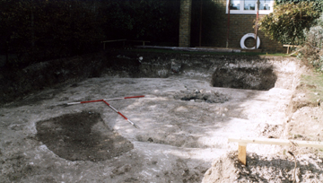
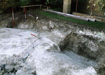
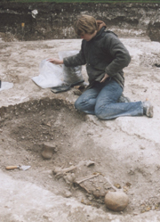
The grave is in the centre of the picture
The fact that one trench stopped only inches short of the grave was initially of great concern
Had the grave been seen and excavated beforehand?
As it turned out we and the grave had been very lucky!
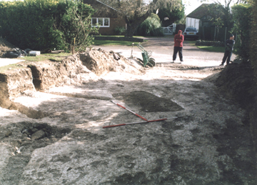
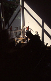
Photo by Emma Boast
Click on the links below if you would
like to read some short summaries
of the specialist reports on the following subjects:
The skeleton
The Beaker
The flint
The story of the land at Beauforts
Click here to read
an overview of the Prehistoric story of the land at Beauforts.
TAU - Thanet Archaeological Unit.
TTA - Trust for Thanet Archaeology.
Boast E.J., Gardner O.W. and Moody G.A. 2006. Excavations at St. Stephen's College, North Foreland, Broadstairs, Kent. Trust for Thanet Archaeology report, Issue 1.
Hart P.C. 2005. ‘Beauforts’, North Foreland Avenue, Broadstairs, Kent. Trust for Thanet Archaeology report.
Perkins D.R.J. 1981. Site 5, North Foreland Avenue, Broadstairs. Interim Excavation Reports 1977-1980. The Isle of Thanet Archaeological Unit, 21-24.
Perkins D.R.J. 1993. An Archaeological Evaluation of a Building Plot at North Foreland Road, Broadstairs. Trust for Thanet Archaeology report.
Natasha Ransom
Jack Russell (left)
I should very much like to thank Natasha
Ransom and
Jack Russell who
both assisted in this excavation. I
would also like to take this opportunity to further thank both of them
for the contributions they have made (and the fun added) to the
investigations of Thanet's archaeology during their time at the Trust.
I would also like to thank Alan Hart
who helped in the lifting of the burial and provided much needed
illumination on a dark early evening in late autumn!
Sincere thanks go to Maggy Redmond for producing an excellent illustration of the Beaker vessel. A perfect case of Archaeology as Art.
Thanks also to Emma Boast and Ges Moody for the digital version of the Beaker illustration and likewise to Steve Clifton and Susan Deacon for the digitisation of the drawings from the excavation.
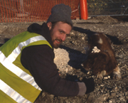
Personal thanks go to the developer Joe Rospo and his groundworks team (two of which can be seen in the picture directly above) for their helpfulness, patience and interest.
Particular thanks go to the owners of Beauforts - Mr. and Mrs. Kimble, for commissioning and funding the work and also for their great interest in the archaeology and history of the plot on which their home now rests.
Finally, but most importantly, I would like to acknowledge the contribution to this project (in what must have been one of his final reports) of the Late Mr. Trevor Anderson, Human Bone Specialist Extraordinaire! A man of great skill and good humour, he is much missed.
Sincere thanks go to Maggy Redmond for producing an excellent illustration of the Beaker vessel. A perfect case of Archaeology as Art.
Thanks also to Emma Boast and Ges Moody for the digital version of the Beaker illustration and likewise to Steve Clifton and Susan Deacon for the digitisation of the drawings from the excavation.
Personal thanks go to the developer Joe Rospo and his groundworks team (two of which can be seen in the picture directly above) for their helpfulness, patience and interest.
Particular thanks go to the owners of Beauforts - Mr. and Mrs. Kimble, for commissioning and funding the work and also for their great interest in the archaeology and history of the plot on which their home now rests.
Finally, but most importantly, I would like to acknowledge the contribution to this project (in what must have been one of his final reports) of the Late Mr. Trevor Anderson, Human Bone Specialist Extraordinaire! A man of great skill and good humour, he is much missed.
Version 1 - Posted 16.12.06
All
content © Trust for Thanet Archaeology