We know from the image in Day 28 of VM_365 that the locations of the prehistoric burial mounds of Neolithic and Bronze Age Thanet can still be traced from the influence they have on the growth of the crops in the fields that lie over them.
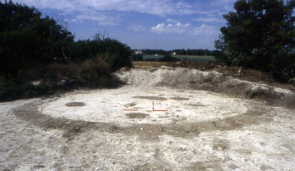
Today’s image, taken at a site at North Foreland near Broadstairs, shows what happens when the thin skim of plough soil that overlies the ditches is removed by archaeologists, using a combination of a carefully controlled mechanical excavator and a final clean up using hand tools.
Once the earth filled ditches and pits underlying the plough soil has been exposed, planning and recording can take place before any further excavation is carried out to examine how deep the surviving ditches may be, and to recover any finds that can help to give a date for the feature.
Careful attention is paid to the irregular patches of dark soil that are enclosed within the ditch because these may be contain the burials that were marked by the ring ditches and their associated mounds as enduring features in the landscape . Other burials were often inserted later, when the mound and ditch surrounding the burial had become a familiar feature in the landscape.
At this stage an archaeological site which was previously known only through images holds the potential to produce physical evidence for the past.