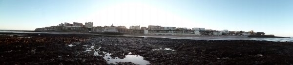
 Today’s image is another in the Our Thanet series of posts. This time it is a view of the coastline from Dumpton on the left side to Viking Bay at Broadstairs on the right.
This part of Thanet’s coast is also subject to heavy erosion, which has formed a distinctive wave cut platform which can be seen in the foreground and the high chalk cliffs that can be seen in the centre of the picture.
Like the other coastal areas shown in our two previous days posts, this landscape would not have been recognisable to the prehistoric inhabitants of Thanet, who may have lived and died on rolling downland slopes that have been cut away by the sea. Their coastlines were much nearer to the vantage point on the edge of the platform where the picture was taken, but were always advancing toward the high central chalk ridge of the isle.
If they were somehow able to return, even the later Iron Age people and the Roman settlers of the area would have trouble placing themselves, their settlements and their buildings which are known to exist at Dumpton on the far left and on the promontory next to Fort House on the extreme right.
Much of the archaeological evidence of past occupation in the landscape between has been lost to the cliff falls that occur regularly following storms at sea and we will now never be able to piece together the whole story of early settlement along the coastline that is shown in today’s image, which makes the knowledge we have gained from previous excavations, many of which were carried out by pioneering archaeologists like Howard Hurd and Dave Perkins and have featured in earlier posts, so much more significant.