Monthly Archives: March 2015

VM_365 Day 265 Art inspired by the Lord of the Manor prehistoric archaeology

VM 265

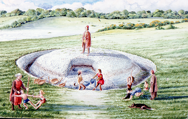
The image for today’s post on Day 265 of the VM_365 project is an illustration by the Trust’s first Director David Perkins, inspired, as much of his work was,  by the landscape and prehistoric archaeology of Lord of the Manor Ramsgate.

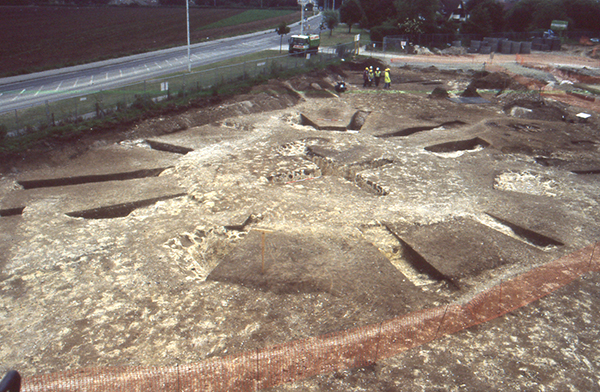
The archaeological excavations that were carried out to explore the many features that were revealed by aerial photography in the area near Lord of the Manor were very significant to understanding the scale of prehistoric settlement in Thanet.

Using their experience of digging several of the major sites  revealed in the Landscape, both Dave Perkins and Len Jay used their artistic skills to record their activities and to interpret the sites they  were uncovering.

The coloured drawing  by Dave Perkins recreates a scene associated with the insertion of a new burial into the mound of one of the prehistoric round barrows located at the crest of the hill, an event that was attested in the archaeological record.

The stark white of the chalk that lies  at a shallow depth below the soil are visible in the cut of the ring ditch and the central mound where it was cast over a primary burial located at the centre. Baskets and shovels show that the ditch has been newly cleaned to refresh the surface of the chalk. The scene shows the mound as having been partly removed, so that another burial can be inserted within the circuit of the ditch. The later burial is perhaps that of a member of family who wishes to be close to a relative, or perhaps a clan member who wants to remind his followers of the source of his power. The burial may be of an unrelated individual who want to claim a connection with the glories of a bygone age. Grieving family members, along with warriors and perhaps elders of the clan are shown outside the ring ditch, while the person to be buried is carried across the ditch to the new grave.

Although the drawing reflects  the archaeological facts that were established from the sequence recovered from the ground, the truth of the scene’s representation of Bronze Age culture can never be known as there are no records to guide our interpretation with certainty.

VM_365 Day 264 Cropmarks record ancient Ramsgate landscape

VM 264
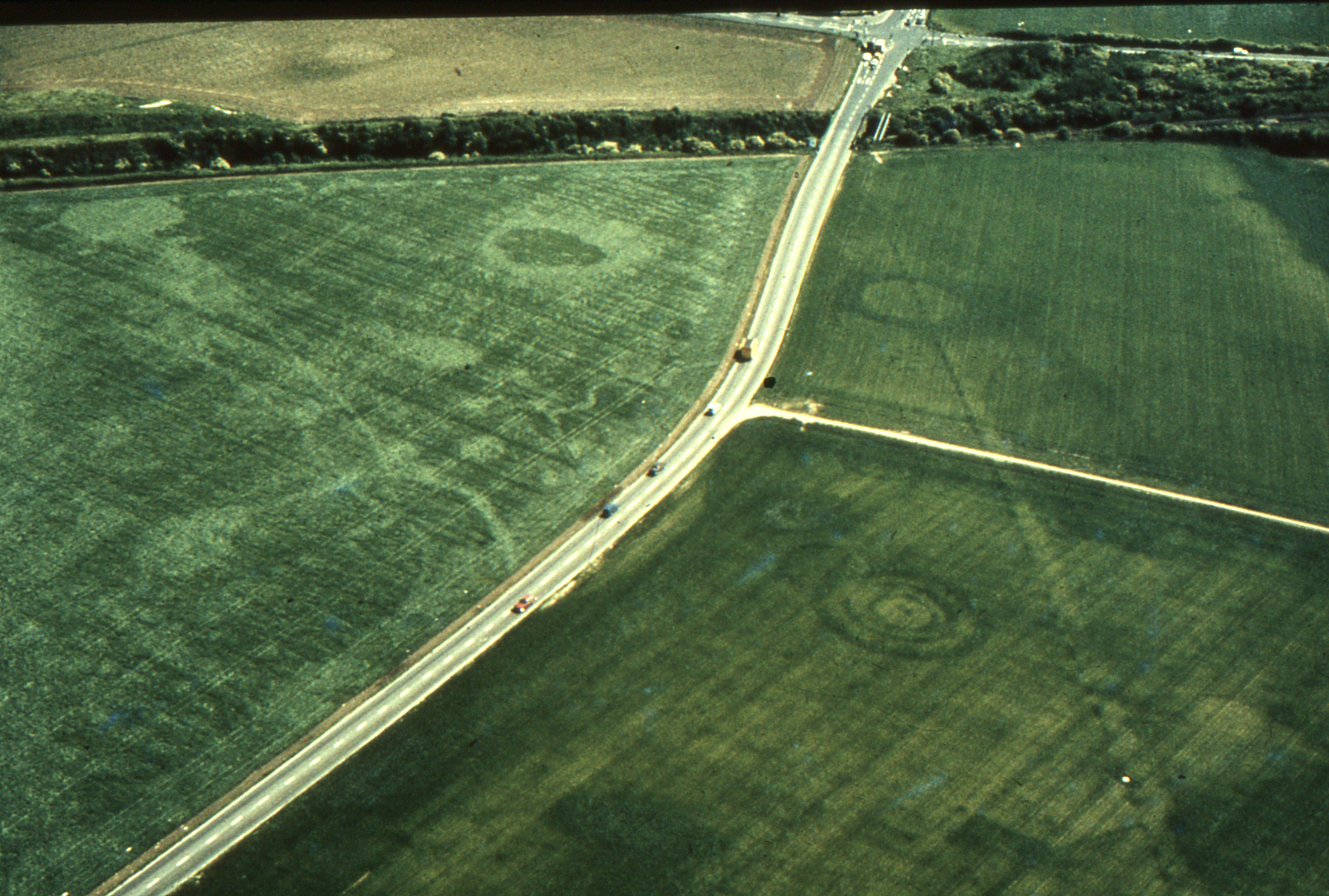
Today’s image for Day 264 of the VM_365 project shows an aerial photograph of one of the most impressive groups of crop mark groups in Thanet’s historic landscape. The picture was taken in the the late 1970’s, from an aeroplane flying over the downland ridge at Lord of the Manor, Ramsgate overlooking Pegwell Bay.

In the photograph, which is facing south east toward Ramsgate, a chalk ridge extends from the lower right corner of the picture toward the top left. The ridge is isolated by the dry valleys that flank it on the right and left hand sides, affording spectacular views over the coastline to the south .

The overflight to photograph the cropmarks took place before several major developments in the road network in the immediate area took place, preserving a record of the  landscape despite the considerable changes  that have happened in recent years. The linear markings and circular shapes that can be seen through the variations in the colour of the crops growing in the field, indicate the locations of buried archaeological features and sites, which have been investigated in many phases of archaeological investigations that were guided by the location of the crop marks since the photograph was taken. The effect of buried archaeological sites  which produced the variations in colour in the growing crop was explained in a drawing produced by Dave Perkins in our VM_365 post for Day 252.

At the junction between a road and a railway cutting that can be seen at the top right of the picture, one of the earliest published archaeological investigations was conducted by William Rolfe, Thomas Wright and Charles Roach Smith, when an Anglo-Saxon cemetery was disturbed by the railway cutting in 1846.  A drawing made of one of the graves was shown on VM_365 Day 225. The Saxon cemetery and the more ancient Bronze Age ring ditches that had occupied the ridge, continued to be investigated in several stages in the later 20th century.  Images of some of the excavations of the Anglo-Saxon cemetery that were carried out in the 1980’s were shown in the VM_365 posts for Day 216 and Day 217.

The three concentric ring ditches of a multi-phase monument, which was first constructed in the Neolithic period and was renewed in the Beaker and Bronze Age periods, can be seen in the bottom right part of the image. A view of the partial excavation of the three ring ditches in 1976 was shown in the image for Day_21.

Archaeological work in this landscape has continued to be carried out with the ditches of an Iron Age settlement being explored in 2012 and in a  training excavation carried out as recently at 2013.


VM_365 Day 263 Crampton’s Water Reservoir for Broadstairs

VM 263

Today’s post for  VM_365  Day 263 shows the disused reservoir located next to Crampton Tower, Broadstairs which was featured in yesterday’s VM_365 post.

The reservoir formed part of the Broadstairs waterworks built by Thomas Crampton in 1859.  Water was drawn from a deep well sunk into the chalk and was stored in the large reservoir covered by this impressive flint and mortar dome. The reservoir had a capacity of 380000 litres and water was pumped by a gas operated engine to a storage tank at the top of Crampton Tower, where gravity created enough water pressure to supply houses nearby.

The dome of the reservoir measures 8.8 metres (29 ft) in diameter and 5.4 metres (18 ft) high. It is constructed of brick inside and flint and daub on the outside of the dome although the upper part is constructed of brick with a chimney. On top of the chimney is a square ventilation box. Like Crampton’s Tower, the reservoir is Grade II listed and together they form a landmark in Thanet’s urban engineering heritage.

For more information about Thomas Crampton and Crampton Tower, visit Crampton Tower Museum in Broadstairs.

VM_365 Day 262 Broadstairs industrial archaeology landmark

VM 262
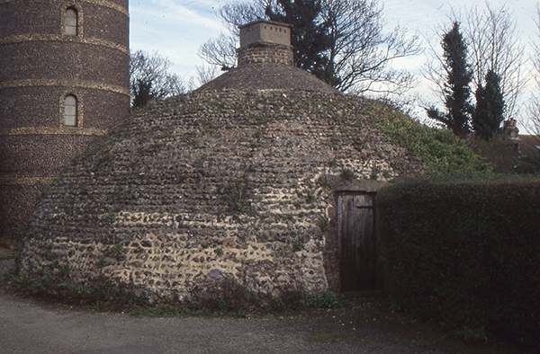
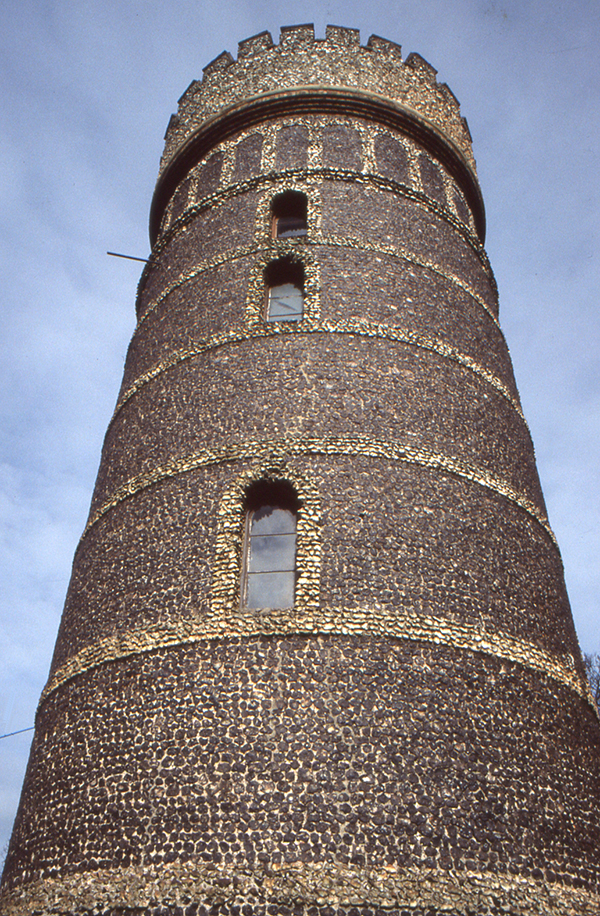
The image for Day 262 of the VM_365 project is of one of the landmarks of Thanet’s industrial archaeological heritage, Crampton Tower at Broadstairs. The tower stands three stories high (24.38m) and is faced with flint, the ubiquitous building material of the small towns and villages close to the sea in Thanet. The divisions between the stories and the windows and doors are picked out with rough flint dressings and string courses. The tower and reservoir are Grade II listed.

The tower was built  to improve the supply of fresh drinking water to Broadstairs and was designed and largely funded by the English civil engineer Thomas Crampton (1816 – 1888),  a railway engineer of great ability, who among many achievements was responsible for a locomotive design, which enjoyed particular success on the continent.

Crampton was born in Broadstairs, the son of a plumber and architect. His parents managed or owned therapeutic baths at Eldon Place, Broadstairs whose warm showers were notably enjoyed by Charles Dickens. Thomas Crampton had been involved in the construction of the Berlin Water works in 1855 and formed the Broadstairs Water Company in 1859.

In the Broadstairs Water Works designed by Thomas Crampton, water drawn from a deep well sunk into the chalk was stored in a large reservoir holding 380000 litres, which was covered by an impressive flint and mortar dome. A gas operated engine, which possibly survives in the tower floor, pumped the water from the reservoir to a tank at the top of the tower, where gravity created sufficient water pressure to supply houses in the nearby area.

Crampton’s water tower is one of the significant steps in the development of Broadstairs  from a cluster of fishermen’s cottages and boat building yards into a small town with the modern conveniences that were expected by visitors to the area and its growing population in the 19th century.

For more information about Thomas Crampton and Crampton Tower, visit Crampton Tower Museum in Broadstairs.

VM_365 Day 261 Two sides to Archaeology at Drapers Mills Margate

VM 261
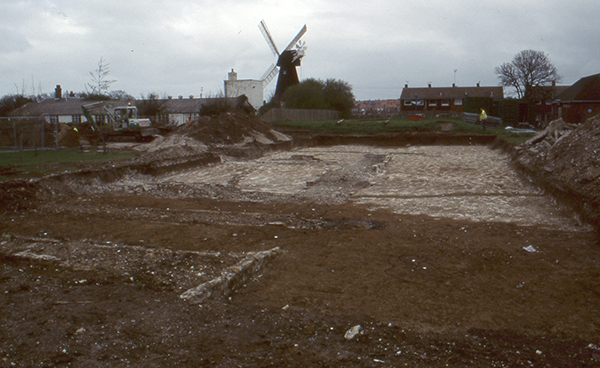
The image for Day 261 of the VM_365 project shows two aspects of the archaeology of Drapers Mills, Margate, both from very different periods but occupying the same landscape.

In the foreground of the image the excavation of a Late Iron Age or Early Roman enclosure is taking place on the playing field of a school. The ditched enclosure is located on the periphery of the site of a Romano-British villa, which was disturbed by the construction of the school in the 1930’s and investigated by excavations between 1959 and 1961 and again in 1981.  The villa probably replaced a small Iron Age settlement, which lay within the enclosure ditch. A filled in chalk quarry from the Roman period in the 2nd century AD, located near the houses to the right of the mill in the image, produced the cast bronze head of a boxer which appeared in the image for Day 17 of the VM_365 project. A wooden box storing a collection of the samian pottery from the villa excavations of 1959 to 1961 in the same area featured in VM_365 Day 86.

In the background at the centre of the image is Draper’s Mill, a smock mill constructed in 1845 by the Canterbury millwright John Holman. A smock mill has a sloping body, with a cap at the top that rotates so that the sails can be turned to face the wind. The windmill is the last survivor of three mid 19th century windmills that that once stood together on this rounded downland hilltop. Draper’s Mill was threatened with demolition in 1965, but was saved and restored in 1968.

Early maps show windmills occupying the hilltop near Drapers Mill as early as the 17th century, and it is likely that there were earlier post mills near the site in the medieval period, standing on similar trestle platforms and possibly within circular enclosures,  to those at St. Peters and Sarre that were shown on VM_365 Day 259 and Day 260. The hilltop site overlooking the bay at Margate has been occupied for many thousands of years and its history is written in the archaeological record, both above and below ground.

VM_365 Day 260 Cropmark of Medieval Post-Mill at Sarre

VM 260

Today’s image for Day 260 of the VM_365 project shows cropmarks  at Sarre recorded during an aerial reconnaissance flight by the Trust for Thanet Archaeology in 1990.

The cropmarks, located to the east of the existing Sarre Mill, show an Anglo Saxon cemetery in the north east quadrant of the picture and a medieval post-mill foundation showing as a ring ditch with a cross in the centre in the south west quadrant.

Evaluation trenching by the Trust in 1990 sampled a number of the Anglo Saxon graves which have previously featured in VM_365 posts and also sampled the cropmark of the post-mill.

The Sarre post-mill is of similar form to the post-mill that was excavated at St Peters, Broadstairs. The ring ditch and cross trench at Sarre contained pottery in 13th and 14th century fabrics indicating that a windmill has stood at Sarre from at least the 13th century.

VM_365 Day 259 Medieval Post Mill at St Peters, Broadstairs

VM_259

Today’s image for Day 259 of the VM_365 project shows the foundations of a medieval post mill which was excavated prior to the construction of the ASDA superstore at St Peters, Broadstairs in 1999.

The Post Mill is the earliest type of Windmill in Europe. The whole structure of the mill, its sails and internal machinery were supported on a central pillar which allowed it to be turned to bring the sails into the prevailing wind. The  central pillar formed part of a trestle structure.  A cross shaped foundation, called a Cross tree, was laid in a trench and supported four angled braces called quarter bars, that propped up the central pillar. The trestle may have been buried in a mound of earth.  A tail pole was used to turn the sails into the wind.

The foundations of the trestle, visible as a cross, are shown in the centre of the ring ditch. In the image above, a number of segments have been excavated through the circuit of the ring ditch which surrounded the mill in which the tail pole would have been swung to turn the mill toward the wind.

VM_365 Day 258 Local Roman copy of a samian bowl form

VM 258

The image for Day 258 of the VM_365 project shows two views of a Roman bowl that was excavated in the grave that has featured in previous VM_365 posts  along withone of two copper alloy bracelets, a pottery beaker  and  bottle and evidence for the hob nailed shoes the young woman was buried with.

This bowl copies the form of a  samian bowl of Dragendorf 44 type. Samian pottery was generally manufactured on the continent in Gaul but like the bottle in the grave, the bowl was actually manufactured on the North Kent Marshes in pinkish red Hoo St Werburgh fabric. This vessel was difficult to date precisely although it must fall in the time bracket of AD.150-250/300; later than the introduction of the form in samian ware and earlier than the end of the Hoo pottery industry.

The bowl  has a chipped flange and there is knife scoring over the interior surface, suggesting that it had been used before being deposited in the grave.

VM_365 Day 257 Roman bottle from Ramsgate

VM 257

Today’s image for Day 257 of VM_365 shows a Roman bottle that was found in a grave excavated in Ramsgate in 2007.  The grave has featured in previous VM_365 posts, along with the finds that were present in the grave, the individual pottery vessels and evidence for the hob nailed shoes the young woman was buried with.

This bottle is classified as Pollard type 169 and has been manufactured in pinkish-brown Hoo St Werburgh fabric. It has a chipped rim, which may have been caused by the flint which was used as a stopper. The vessel dates between  c.AD.150-250/300.


VM_365 Day 256 Colour Coated Roman Beaker from Ramsgate Roman Grave


VM 256
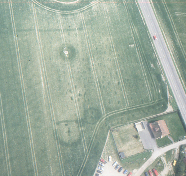
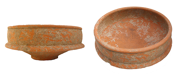
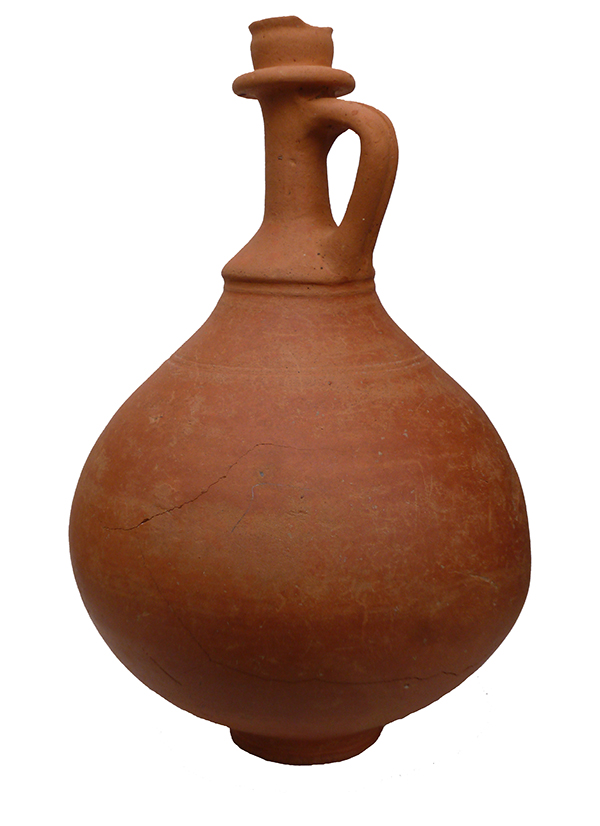
The image for Day 256 0f the VM_365 project is of a Roman Beaker found in a grave excavated in Ramsgate, which has featured in a series of previous VM_365 posts, along with the finds that were present in the grave and evidence for the hob nailed shoes the individual was buried with.

The beaker is in a colour coated ware, which means that the light coloured fabric of the pottery has been totally covered with a slip of dark glaze. The exterior of the pot was decorated further buy adding a white painted lattice pattern. The beaker was possibly manufactured in Gaul, in 3rd or 4th century AD.

Perhaps a story of greater human interest represented by this vessel are the impressions of the fingers of someone who grasped the body of the vessel before the clay had dried and left a lasting memorial of their otherwise unrecorded existence.

The survival of the intact vessels on the small archaeological site, despite the demolition of the buildings above and the use of a large toothed mechanical excavator bucket to grub out the foundations of the building that stood above it, is a matter of incredible luck.