Category Archives: Margate

VM_365 Day 358 La Tène style vessel from Fort Hill, Margate

VM 358

Today’s image for Day 358 of the VM_365 project shows a fine, mid to late Iron Age pottery vessel. This vessel was excavated from a pit on an Iron Age settlement site at Fort Hill, Margate in the late 1990’s which has previously featured on Day 82 of the VM_365 project.

The pottery sherds are decorated in La Tène II style and date to c. 250-125 BC. The vessel, probably a product of a local pottery industry in the continental style,  is decorated with Iron Oxide pigment which colours the swirls in the decoration as dark red.  A vessel of a similar style was excavated by Dr Arthur Rowe in 1924 at Tivoli, Margate and featured on Day 226 of the VM_365 project

VM_365 Day 356 Historic Margate ancient and modern

VM 356The image for day 356, which continues our intermittent Our Thanet series is a panoramic view of part of Margate, taken across the roof of the Margate Winter Gardens and facing the terrace of houses standing on Fort Hill. The roof top of the Turner Centre, overlooking the historic Margate Pier can be seen on the far right of the image.

Although much celebrated for its recent arty renaissance in association with the Turner Contemporary Galery and the the Dreamland theme park which opened its doors again this weekend, this area is one of Margate and Thanet’s richest areas for the archaeology of the Iron Age and Roman period.

An Iron Age burial lying in a circular pit cut into the chalk geology was found during the demolition of parts of the former Cobbs Brewery complex and the construction of a  Police Station which stands behind the last buildings at the right hand end of the terrace.

The remains of post built structures and pits also dating to the Iron Age indicated that a settlement had been present and a fine La Tene style decorated vessel found in a large pit nearby demonstrated something of the high status of the settlement.

Behind the houses at the centre of the image, in the area of Trinity Square redevelopment has revealed a dense cluster of Iron Age and Roman features cut into the chalk, these include several storage pits and at least three more pit burials. Roman cremations contained in pottery vessels were found in construction work in the 19th century, in the area behind the right hand end of the terrace of buildings shown in the picture.

The terrace of houses in today’s image follows the crest of one side of the deep valley that carries the Dane Stream to the Bay at Margate. On the downslope beyond the terrace are the subterranean passages of the Margate Caves and the Shell Grotto.

Until it was  sealed in a culvert in the Early 19th century the Dane Stream ran along the base of the valley parallel with the terrace in the image. The water supply for the Reeves and Co. Soda Water plant was drawn from this stream. Nearby, at the junction with Trinity Square and King Street at the bottom the valley is the restored 15th century house, formerly known as the Old House but now called the Tudor House. Adjacent to the house are the remains of a 17th century Malt House, which was  associated with Cobbs Brewery which extended over a large part of the valley slope at Fort Hill.

Margate continues to occupy a place in the nations heart as a quintessential seaside town. The image of the knife we posted on Day 95  shows that even the town’s newer attractions like  Dreamland, restored and re-opened as an attraction to a new generation of visitors produced its own historic artefacts to be  discovered by contemporary archaeologists.

Such a significant gathering place generates its own archaeological footprint and the ancient discoveries from the same area show that the landscape around Margate has been a place of gathering for over two millennia.

VM_365 Day 347 Reeves and Co. Ltd, Margate

VM 347

Today’s image for Day 347 of the VM_365 project shows a glass soft drinks bottle from the mineral water manufacturers Reeves & Co Ltd who operated between 1849 and 1964 at Margate. This bottle probably dates from around the late 19th century to the early 1900’s and reads ‘Reeve and Co Margate’ in the outer oval and ‘Trade Mark’ in the inner oval.

The Reeve and Co. Mineral Water factory was established within an enclosed yard at Hawley Street in 1849 where they constructed a purpose built facility to draw spring water from the Dane Stream via a well or a culvert which was then carbonated on site. The carbonated water was a popular beverage among holiday makers at Margate.

In the later 19th century Reeve and Co. engaged in a tremendous variety of trades centred around wholesale trade, processing and distribution and also had a retail shop on Hawley Street, the frontage of which can still be seen pronouncing 70 years in operation which dates the shop front to around 1909.

A lively narrative of the operation of the plant was given in the local newspaper, Keble’s Gazette in January 1889 describing how as many as 120 people were kept employed in a range of processes that required very different skills among the staff from fish gutting to cutting and soldering tin cans for storage. The key to Reeve’s business was the procurement, storage, processing and distribution of commodities. It is clear from the description in Keble’s gazette that the factory bridged a gap between the labour intensive trades of the fisheries and agriculture that supported the rural economy, and the intensive division of labour that represented the new industrial manufacturing processes of the later 19th century. In the final passages of the description it is implied that the factory was also fulfilling a social role in providing a continuity of employment in the towns population whose traditional working patterns were diminishing in importance and who were being driven into poverty.

Reeves and Co. Ltd connected the historic import and export functions of Margate as a sea trading port and the seasonal products of the local agriculture and the fisheries with the increasing demand for food in the growing cities, particularly London. Much as London exported its leisure time to the coast, the coastal and agricultural products were sent back along the trade networks to the city, preserved, bottled and tinned.

With the general decline of Britain’s industrial cities and trading networks in the period after World War Two the type of fetching and carrying business Reeve and Co. were engaged in had to compete with increased international imports and declining demand from the failing industrial towns. The niche markets and local networks were no longer sufficient to support it and the company closed in 1964.

VM_365 Day 346 What about the box? Imports from Colchester.

VM 346

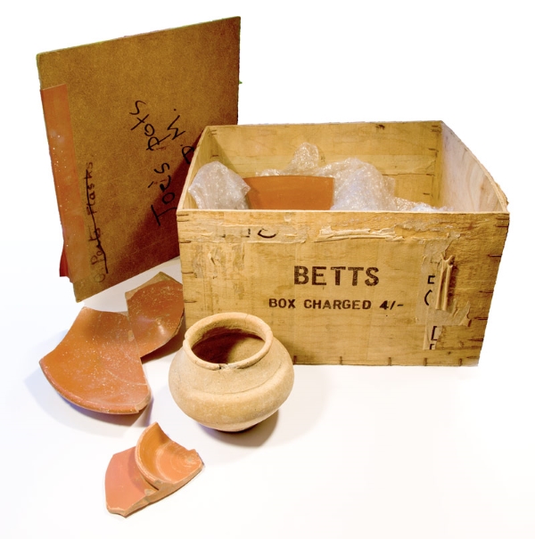
Today’s image for Day 346 shows the wooden box that was used to store some of the Roman pottery excavated at the Roman building near Drapers Mill by Joe Coy in the late 1950’s and 1960’s which featured in yesterday’s VM_365 post for Day 345. The wooden box holding Joe Coy’s Roman pottery dates to the late 1950’s – 1960’s, comtemporary with the time the dig at Drapers Mill was carried out and itself has a story to tell us.

Museum stores house thousands of artefacts and when visiting the stores it is often not long before you see an old tobacco tin, wooden matchbox and the like from the 20th century that had been pressed into service as a make-do receptacle for a find. This was a time when Tupperware, cardboard and plastic wrapping were generally less common and before there were stricter museum curation policies (that specify how materials are to be received by the curating museum). So, just as with a visit to the family shed, you can see how, what were familiar items of recent times, were opportunistically utilized for safe storage.

Coming across such containers can jog the memory and be a fascinating encounter as sometimes what was ubiquitous, valueless and discardable packaging, say 70 years ago, now has a story to tell. Occasionally this is as insightful as the artefact within. In those times we consumed less, things were less easy to replace, and there was more of an attitude of ‘make-do and mend’; what items came in were often carefully designed and very well-made: here was a chance for the prudent 20th century recycler to find a new use for old packaging. What was to hand was helpfully taken into service, not so much to save cash but more likely because there were limited alternatives.

We only have to go back a few decades to the 1960s to be within that time and we can see that Joe Coy’s best pottery finds from the excavations at Drapers Mills from the turn of that decade came to be housed in a robust wooden box convenient for shelving and for transport for when the finds were needed for display or to show the pottery experts.

The box is made of thin ply-wood and its measurements and markings are in imperial standards for it pre-dates the switch to decimalization in 1971. Accordingly it measures 11 by 10 inches and has a height of 6¾ʺ. It had been marked in now fading black-ink by stencilling or stamping with the name ‘BETTS’. It was seen recently by Pete Nash who recognized it immediately as coming from the Betts toothpaste tube factory at Colchester.

Also marked on one side (more obviously by stencilling and in a different type-face) are the contents, described in light traces as ‘TUBES’ with what is likely to be the quantity given but which cannot now be read clearly. The price is given by means of the same stencil as ‘BETTS’ telling the reader ‘BOX CHARGED 4/-’ in what we call nowadays ‘old money’ namely four schillings (20p in today’s decimal currency). The ply-wood is ⅛ of an inch thick, with metal staples used to bind the sheets together. This makes for a container it is very sturdy but light and doubtless the dimensions relate to the size of the tubes inside and their safe transit and housing.

The tubes of toothpaste originally stored in the box were almost certainly of soft metal and shorter than today, so may have sat in two rows within the box. Masking-tape had been added at a later stage, probably to secure an improvised lid as the original top is missing (was that perhaps used in a role as a tray as we might use a shoe box lid today or had it been broken on opening?). Did the original lid say more about the content? A makeshift lid was provided when it was pressed into service to store the pottery, perhaps in the 1960s or 1970s, made of ‘hardboard’ which is another material that was ubiquitous at the time, being used in light carpentry, but now rarely seen. This was also something likely to be simply convenient to hand which has been cut to just lie over the top of the box. It too is inscribed, but this time with summary information on the present contents and in marker pen, short and to the point “Joe’s pots DM.”

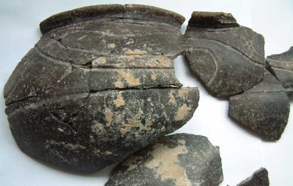
Aptly the box and perhaps what it originally held were imports to Thanet, just as it contains imports from the Roman era in its present use. One of these, a whole globular beaker, as featured in yesterday’s post for Day 346 of the VM_365 project, is a type known from Roman Colchester, one that may have been made there, which would be a striking coincidence.

Of course the reuse of former packaging is well-attested through the ages: from Roman wine and oil amphorae seen reused as caskets for burials (with examples known on Thanet and in north-east Kent) to the tea-chests which were an everyday item seen in second use in ‘storage and removal’ through the second half of the 20th century. Doubtless old jam jars will be employed for new home-made jams this summer, some maybe first had jam from Tiptree, near Colchester.

The Betts factory which was still operating in the 1960s closed to be redeveloped recently for housing. Joe Coy’s box has become an artefact and its history ties it in time to the important excavations at Drapers Mills that occurred when the box was itself young. What happened to all the thousands of other boxes of this type dispatched from the Betts factory and are there other surviving examples from Thanet?

Dr Steven Willis (University of Kent), Photo: Lloyd Bosworth (University of Kent). Thanks to Pete Nash of Colchester.
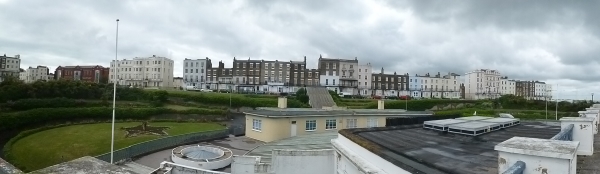
VM_365 Day 345 Wooden box stores Roman pottery collection. Part 2

VM 345
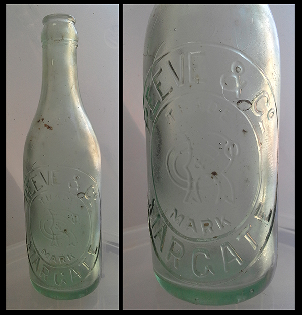
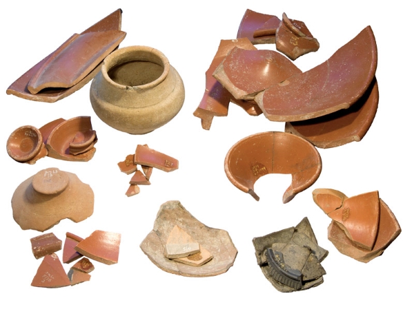
Today’s  image for Day 345 of the VM_365 project shows a selection of pottery from excavations carried out by Joe Coy at Draper’s Mill, Margate during the late 1950’s and early 1960’s. These vessels and sherds were stored in a wooden box and a general exploration of the samian contents have previously featured on Day 86 of the VM_365 project.

A deeper dig into Joe Coy’s box of Roman pottery reveals more about the site and the collection. The ensemble features samian ware very prominently and some is shown in this photo; it is clear that this ‘boxed set’ is a selection of items considered particularly interesting by the excavator.

Samian ware was the fine imported table ware of the Roman period which was relatively expensive and, indeed, rather ‘flashy’ perhaps when set on the Roman dining table alongside other locally produced vessels. Several vessels here have the stamp of their maker present. Leaving aside the three complete or near complete vessels in the foreground of the post from Day 86 there are a number of vessels which are represented by several sherds and in these cases much of the vessel is present. This being so we might speculate: was there an accident one day when several vessels were broken and needed to be discarded?

Two of the larger samian vessels are bowls made at Lezoux in Central Gaul, now located in modern France (top right). From the reading of the names of the makers (or is it the name of the workshop?) impressed into the floor of the vessels, together with their shape, it is possible to say with confidence that they date to the middle of the second century AD. The makers stamps show them to be the work of Paterclinus and Patricius ii. The most frequent vessel form amongst the samian is, however, the conical cup (Dragendorff’s type 33) though this is present in a variety of sizes.

The small whole buff-coloured globular vessel is a beaker (Jason Monaghan’s type 2C6) and is a form seen at other sites in the region such as Colchester. Pots in this form have likewise been recovered at Cooling in north Kent (on the Hoo Peninsula) where there was a major pottery industry at this time.

The samian includes first century ware, while a little later in date is one of the type 33 cups which is a particularly fine example of Hadrianic date and more orange than red (bottom right). Later samian forms occur too. One of these late samian vessels came to the Drapers Mills site from Trier, then in Eastern Gaul, in the early third century and is noteworthy in lacking the finesse of earlier samian wares. Present too in the box are other non-samian Roman finer wares including a sherd from a beaker from the Nene Valley near Peterborough, and the lower part of a vessel with gold mica-dusting giving it an intentionally attractive glittery appearance (on the left but with glitter not caught in this photo).

Another fine table item present is of much more recent date being a decorated base fragment of black Wedgewood Jasperware (bottom, right of centre on top of a small pile of fine Roman greyware sherds) which was perhaps originally thought by the excavators to be fine Roman ware. Samian and Nene Valley beakers were the equivalent to Wedgwood products in their time and Jasperware often featured goddesses and other imagery drawn from the classical world so their companionable boxing-up here seems very apt.

Dr Steve Willis

Photos by Lloyd Bosworth, University of Kent.

VM_365 Day 340 Holly Lane, West Northdown

VM 340
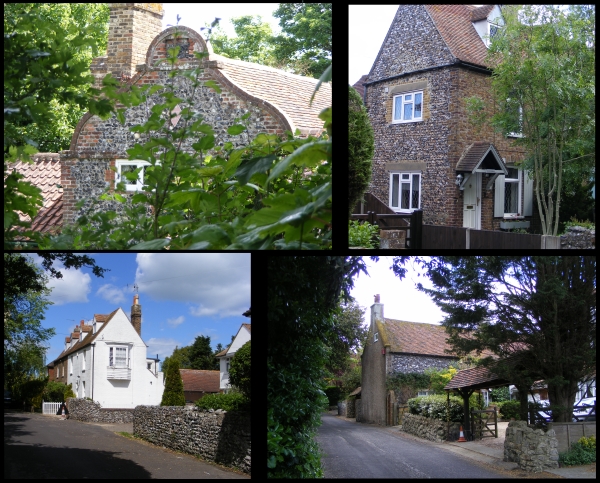
Today’s image for Day 340 of the VM_365 project shows a series of images of another of our Hidden Hamlets in Thanet, located around Holly Lane at West Northdown, Cliftonville.

Holly Lane is located a short distance south of Omer Avenue which featured on Day 338 of the VM_365 project. Before the area aroiund Holly Lane became part of the residential suburbs of Cliftonville, it was occupied by two farms; Hospital Farm and West Northdown Farm, which later became Holly Farm. Between 1907 and the 1930’s the area around both farms began to be in-filled with residential housing as agricultural land was sold off. Hospital Farm was completely demolished. By the 1960’s most of the area around Holly Lane was completely in-filled.

Evidence of its former isolated and agricultural character still exists along Holly Lane and Old Green Road. The oldest building, Grapevine Cottage (top left), is located in Holly Gardens, set back off Holly Lane and is believed to date from 1620 or earlier. It was originally two labourers cottages constructed of brick with curved end gables.  In the 20th century the building was altered to become a single house.

Other evidence of the 18th and 19th century agricultural origins exist in the form of flint boundary walls and flint and brick cottages.

VM_365 Day 338 West Northdown, Cliftonville

VM 338
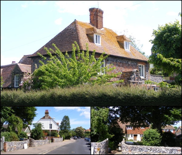
Today’s image for Day 338 of the VM_365 project continues our Hidden Hamlet series and shows the surviving elements of two farms at West Northdown, Cliftonville which are now completely surrounded by suburban development.

The main image at the top shows West Northdown Farmhouse which is located on Omer Avenue. The former farmhouse was originally constructed in 1652 and the date is recorded on the west side of the house in brick. This lovely Dutch gabled building is built of squared knapped flint with brick dressings; the first floor is decorated with red brick in a diaper pattern.

West Northdown Farmhouse was largely still surrounded by agricultural buildings and by open farm land until the early 1900’s when it is labelled on Ordnance Survey maps as being part of Dairy Farm.  A second farmyard located around 50 metres or so south east of the farmhouse is labelled as Omer Farm. By the publication of the 1936 Ordnance Survey map both Omer Farm and Dairy Farm have been sold off, the agricultural buildings demolished and new houses erected along the newly constructed Omer Avenue which extends north between the locations of the two farms.

The only surviving original element of Omer Farm appears to be a flint wall which extends along the western side of the street frontage on the opposite side to West Northdown Farmhouse. An interesting building (bottom left) is located on Omer Avenue, set back from the street front and located in what would have been one of the yards of Omer Farm. This building at first glance appears to be of a similar date to West Northdown Farmhouse but is in actual fact a cottage built in 17th century style in 1933 using old materials probably recycled from the demolished farm.


VM_365 Day 327 The Treasury, St John’s Church, Margate

VM 327

Today’s image for Day 327 of the VM_365 project shows the Treasury which was constructed on the north east corner of the parish church of St John the Baptist, Margate which featured on Day 324 of the VM_365 project.

This single storey addition to the church was constructed around 1500 AD from coursed Ragstone and incorporating a crenellated parapet and traceried windows.  The Ragstone is a distinctly different building material to the rest of the church and was shipped in from the Maidstone area; the rest of the church is constructed mainly of flint which was easily obtainable locally.

Although originally built to be the church treasury, for the storage of the church’s valuables, this structure was later adapted to store shot and gunpowder for the town fort and was also used by the Churchwardens to administer poor relief for the parish. In the early 18th century it became the church vestry.

References/Further Reading

Berg, M. and Jones, H.  2009. Norman Churches in the Canterbury Diocese. The History Press.

Colyer, R. 2012. The Parish Church of St John the Baptist, Margate. A short guide. http://www.stjohnschurchmargate.org.uk/churchfamily-history/the-parish-church-of-st-john-the-baptist-margate-a-short-guide-5/

Historic England 2015. The National Heritage List for Britain: The Parish Church of St John the Baptist. List entry no.1351103. http://list.historicengland.org.uk/resultsingle.aspx?uid=1351103&searchtype=mapsearch

Scurrell, D. 1982. The Book of Margate. Barracuda Books.


VM_365 Day 324 The parish church of St John the Baptist, Margate

VM 324
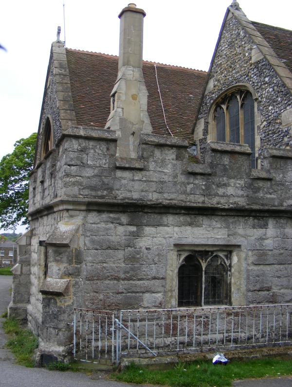
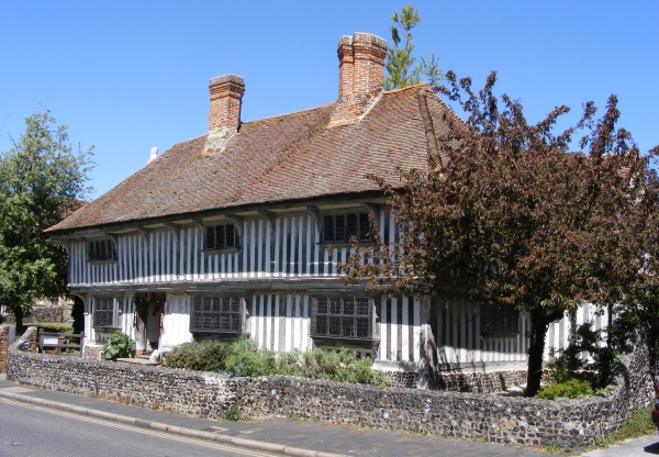
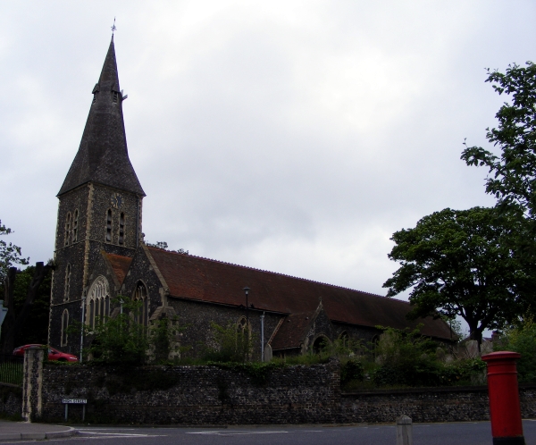
Today’s image for Day 324 of the VM_365 project shows the large parish church of St John the Baptist, Margate. It is located on high ground about a mile inland from the coast and would have been widely visible throughout the parish before the town became more built up in the 19th and 20th centuries. The church was constructed mainly in knapped flint with some ragstone used later.

St John’s was a chapel to the mother church at Minster until 1275 when it became a parish church in its own right. There may have been a church here as early as the mid 11th century although parts of the original surviving Norman church were probably constructed in the mid 12th century. The Norman church was much smaller than the current structure although it did have a north aisle of two or three bays and part of the existing north aisle and the chancel arcades date to this phase. The church was significantly extended to the west later in the 12th century and the rest of the north and south aisle were added.

Some of the south and north arcades were replaced in the 13th century possibly to resolve problems with the structure which may have the result of a fire or a collapse. The very tall northwest tower was constructed in the 13th century and the spire was added in the 14th century.

In the late 15th to early 16th century, a treasury built of kentish ragstone with a low pitched roof and crenellated parapet was built at the north east end of the church which suggests that the church had become wealthy enough to need somewhere to secure valuables. It later became the place where the churchwardens administered poor relief and as a secure store for gunpowder and weapons.

The exterior of the church was heavily restored in the 1870’s by the well known architect Ewan Christian.

References/Further Reading

Berg, M. and Jones, H.  2009. Norman Churches in the Canterbury Diocese. The History Press.

Colyer, R. 2012. The Parish Church of St John the Baptist, Margate. A short guide. http://www.stjohnschurchmargate.org.uk/churchfamily-history/the-parish-church-of-st-john-the-baptist-margate-a-short-guide-5/

Historic England 2015. The National Heritage List for Britain: The Parish Church of St John the Baptist. List entry no.1351103. http://list.historicengland.org.uk/resultsingle.aspx?uid=1351103&searchtype=mapsearch


VM_365 Day 320 The Tudor House, Margate

VM 320

Today’s image for Day 320 of the VM_365 project shows another of Thanet’s earliest standing buildings, the Tudor House at Margate. The house is of timber framed transitional type; a cross between the open hall house of the medieval period and the early modern house. The transitional house retained the high and low end arrangement of rooms that were seperated either side of the open hall  during the medieval period but did not have the open hall and was instead storied along thefull length of the first floor.

This high status timber framed building dates to the period around 1525-1550.  It was originally built for a wealthy household, possibly a farmer with additional sources of income and was heavily restored close to its original form in 1950 after having previously being subdivided into cottages sometime in the early to mid 19th century.

The Tudor house has a continuous jetty along the first floor and is  supported at the corners by dragon posts. It also has a jettied roof  supported internally by crown posts. In the western end of the building, where the service rooms were located, is a chalk and flint constructed cellar. The house was heated by two brick built chimneys.

The original windows, some of projecting oriel type, were glazed throughout, a conspicuous sign of the wealth of the owners of the building. Projecting Oriel windows can be seen on the ground floor in the image above.

Sometime in the 17th century an extension was added to the eastern end of the building to accomodate a larger stairway and the parlour ceiling was lavishly decorated with a plaster ceiling embellished with Tudor roses, grapevines and other motifs common at the time.

A 17th century malt house which featured on Day 67 of the VM_365 project was constructed to the rear of the building and its remains can still partly be seen  today.

The Tudor House is open to view by the public and is well worth a visit.

Reference/Further reading

Twyman, M and Beeching, A. 2003. The Old Tudor House at Margate. Margate Historical Society Local History Study Document Number One. Revised 2006.

Austin, R. 2014. Tudor House, Margate. In Canterbury’s Archaeology 2012-2013. Annual Review of Canterbury Archaeological Trust. pp 21-22.