Category Archives: Lord of the Manor

VM_365 Day 341 Unique vantage points and prehistoric sites

VM_341

The image for Day 341 is another in the series of Our Thanet posts, showing locations that play an important part in the exploration and appreciation of Thanet’s heritage.

The image shows a view taken facing south and south west from a downland hill top at Lord of the Manor, Ramsgate when part of the ring ditch associated with a Bronze Age round barrow was partly exposed in a training excavation in 2013.

Although it is partly obscured by trees and buildings that have grown up since a railway cutting was pushed through the chalk hillside in 1847, it is still possible to see the vista across the low lying bay that could be seen from the vantage point of the raised central platform enclosed by the ring ditch. From the centre of the mound the horizon falls away in a wide sweep from the north east to the south, giving a view across Pegwell Bay.

It can be no coincidence that a location commanding such an impressive view was chosen for the location of  such a major monument in the Bronze Age. Everywhere on Thanet where such unique points which command similar impressive views over the landscape can be found, there are also concentrations of prehistoric monuments, some unusually large in size or very complex such as the Lord of the Manor 1 multi phase monument which featured all the way back on Day 21 of the VM_365 project. Artistic reconstructions of the development of the landscape over time featured in an earlier series of VM_365 posts starting on Day 265.

This unique landscape is increasingly under pressure from development and it may soon not be possible to see what the prehistoric inhabitants of the Isle could see from the vantage points of the downland hilltops.

VM_365 Day 266 The barrow reconstruction drawings get more complicated

VM 266

The image for Day 266 of the VM_365 project is the second in a series of images drawn by Dave Perkins, reconstructing the sequence of event associated with a funerary monument that was revealed in excavations at Lord of the Manor, Ramsgate.

In today’s image, the single ring ditch and mound that was shown in yesterday’s picture is being renewed, ready to receive another burial. The original ring ditch and its mound, now compressed and discoloured, have been sealed under fresh chalk which is being dug from a new ring ditch with a greater diameter than the earlier one. The circuit of the new ditch is  interrupted by a causeway, where a stretch of the circuit was not excavated. It is a process like this that created the concentric circuits of ditches that show up so well in the cropmark posted on VM_365 Day 264.

The location of the barrow is closely based on the landscape of the Lord of The Manor site, with the land falling away into a deep dry valley, which is shown covered with woodland. The sweep of the valley leads to the sea at Pegwell Bay in the upper right hand side of the picture. On the left side of the image a funeral procession is making its way up the side of the valley toward the newly refurbished barrow.

It is still possible in the present day to stand near the site of the barrow and see the same view over the bay which would have been presented to the prehistoric people of the area.  It was this experience of the landscape that Dave Perkins used to draw his reconstruction images.

Further analysis of the landscape has shown that there are only a few sites in Thanet’s landscape where such an uninterrupted view is possible and it becomes clear from considering the landscape that sites were carefully chosen to provide such a panoramic view. Excavations have shown that some were used over many thousands of years to locate settlements, gather for ceremonies and to create structures where the dead could be buried.

Once again we can reconstruct the facts that are presented by the archaeological features on the ground, but can never really confirm the reasoning behind the choice of location which is so well captured in the drawing. Was it to assert a power or domination over the landscape or to enhance the visibility of the monument from other sites? Motives may have changed over time passing from willful choice into tradition whose meanings were lost in the passage of time.

The true motives are lost without the record of contemporary voices, but we can explore possible meanings through attempts at reconstruction like the drawings in this series of posts. There are questions to ask about this reconstruction: was the natural environment so open and free of the influence of man as it is shown? Was it as simple a task to create a barrow as is suggested? The ring ditches of the many barrows that have now been excavated in Thanet have demonstrated that they are often perfectly circular with regular and symmetrical profiles throughout the circuit, despite the hard chalk rock that had to be cut to create them. It is immediately possible to suggest the picture could be made more accurate with the addition of some figures carrying out some quite complex surveying and architectural control over the cutting of the ditch as well as an indication of the greater amount of labour that went into cutting away the chalk in such quantity. Our ideas progress through such criticisms of the reconstruction, which perhaps leads in the future to new images that take new ideas on board. Sadly they will not have the benefit of Dave Perkins’ wisdom and experience to inform them.

VM_365 Day 265 Art inspired by the Lord of the Manor prehistoric archaeology

VM 265

The image for today’s post on Day 265 of the VM_365 project is an illustration by the Trust’s first Director David Perkins, inspired, as much of his work was,  by the landscape and prehistoric archaeology of Lord of the Manor Ramsgate.

The archaeological excavations that were carried out to explore the many features that were revealed by aerial photography in the area near Lord of the Manor were very significant to understanding the scale of prehistoric settlement in Thanet.

Using their experience of digging several of the major sites  revealed in the Landscape, both Dave Perkins and Len Jay used their artistic skills to record their activities and to interpret the sites they  were uncovering.

The coloured drawing  by Dave Perkins recreates a scene associated with the insertion of a new burial into the mound of one of the prehistoric round barrows located at the crest of the hill, an event that was attested in the archaeological record.

The stark white of the chalk that lies  at a shallow depth below the soil are visible in the cut of the ring ditch and the central mound where it was cast over a primary burial located at the centre. Baskets and shovels show that the ditch has been newly cleaned to refresh the surface of the chalk. The scene shows the mound as having been partly removed, so that another burial can be inserted within the circuit of the ditch. The later burial is perhaps that of a member of family who wishes to be close to a relative, or perhaps a clan member who wants to remind his followers of the source of his power. The burial may be of an unrelated individual who want to claim a connection with the glories of a bygone age. Grieving family members, along with warriors and perhaps elders of the clan are shown outside the ring ditch, while the person to be buried is carried across the ditch to the new grave.

Although the drawing reflects  the archaeological facts that were established from the sequence recovered from the ground, the truth of the scene’s representation of Bronze Age culture can never be known as there are no records to guide our interpretation with certainty.

VM_365 Day 264 Cropmarks record ancient Ramsgate landscape

VM 264Today’s image for Day 264 of the VM_365 project shows an aerial photograph of one of the most impressive groups of crop mark groups in Thanet’s historic landscape. The picture was taken in the the late 1970’s, from an aeroplane flying over the downland ridge at Lord of the Manor, Ramsgate overlooking Pegwell Bay.

In the photograph, which is facing south east toward Ramsgate, a chalk ridge extends from the lower right corner of the picture toward the top left. The ridge is isolated by the dry valleys that flank it on the right and left hand sides, affording spectacular views over the coastline to the south .

The overflight to photograph the cropmarks took place before several major developments in the road network in the immediate area took place, preserving a record of the  landscape despite the considerable changes  that have happened in recent years. The linear markings and circular shapes that can be seen through the variations in the colour of the crops growing in the field, indicate the locations of buried archaeological features and sites, which have been investigated in many phases of archaeological investigations that were guided by the location of the crop marks since the photograph was taken. The effect of buried archaeological sites  which produced the variations in colour in the growing crop was explained in a drawing produced by Dave Perkins in our VM_365 post for Day 252.

At the junction between a road and a railway cutting that can be seen at the top right of the picture, one of the earliest published archaeological investigations was conducted by William Rolfe, Thomas Wright and Charles Roach Smith, when an Anglo-Saxon cemetery was disturbed by the railway cutting in 1846.  A drawing made of one of the graves was shown on VM_365 Day 225. The Saxon cemetery and the more ancient Bronze Age ring ditches that had occupied the ridge, continued to be investigated in several stages in the later 20th century.  Images of some of the excavations of the Anglo-Saxon cemetery that were carried out in the 1980’s were shown in the VM_365 posts for Day 216 and Day 217.

The three concentric ring ditches of a multi-phase monument, which was first constructed in the Neolithic period and was renewed in the Beaker and Bronze Age periods, can be seen in the bottom right part of the image. A view of the partial excavation of the three ring ditches in 1976 was shown in the image for Day_21.

Archaeological work in this landscape has continued to be carried out with the ditches of an Iron Age settlement being explored in 2012 and in a  training excavation carried out as recently at 2013.


VM_365 Day 225 An Antiquarian Illustration of an Anglo Saxon grave

VM 225

The image for Day 225 of the VM_365 project is an illustration of one of the Anglo-Saxon graves from Ozengell, Ramsgate drawn by F. W. Fairholt in the mid 19th century.

The Anglo Saxon cemetery at Ozengell was discovered in 1846. While workmen were digging a cutting for the new South Eastern Railway line from Ashford to Margate a large number of graves were dug through in fields near an Inn on the road to Canterbury from Ramsgate called Lord of the Manor. Many of the graves within the route of the cutting were destroyed and their artefacts sold off by the workmen before any record of them could be made.

However, William Rolfe, a Sandwich Antiquarian, managed to secure a number of the artefacts from the cemetery for recording and was able to arrange for around thirteen undisturbed graves to be opened for investigation by a group of antiquarians including Charles Roach Smith, Thomas Wright and the illustrator,  F. W. Fairholt who drew many archaeological finds of the period.

Fairholt drew this image during his visit and it is an excellent representation of the layout of the one of the graves. The illustration shows the skeleton of a male, with the remains of a shield on his chest,  a spear on his left side, an iron knife at his right hip, a short sword across his pelvis and a pottery vessel at his right shoulder.

The cemetery was not investigated again until over 100 years later, during the 1960’s, 1970’s and early 1980’s and most recently in 2013.  Artefacts from graves investigated during the 1980’s have featured on Day 204, Day 206, Day 209 and Day 211 of the VM_365 project.

Fairholt’s meticulous attention to detail means that his contemporary grave plan gives a level of information comparable with those made over 100 years later.


VM_365 Day 217 Art and Anglo-Saxon archaeology

VM 217

The image for Day 217 of the VM_365 project continues yesterday’s series of images showing artistic interpretations by Len Jay of the archaeological investigation of Anglo-Saxon archaeology in Thanet .

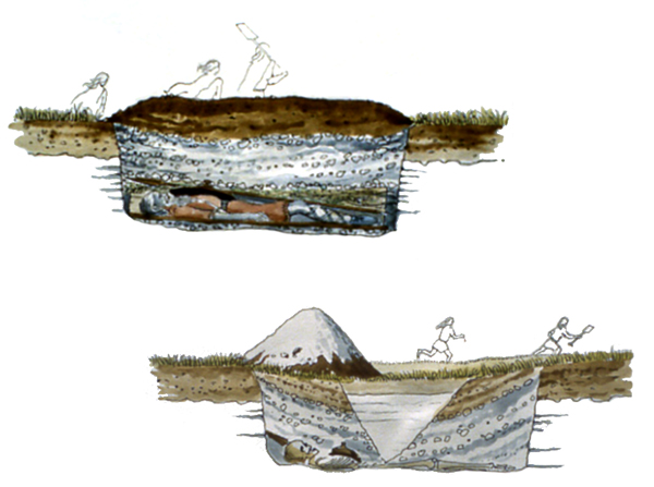
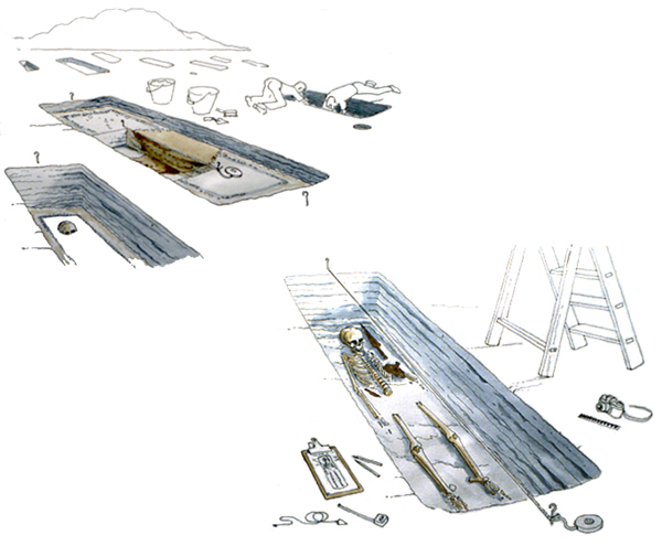
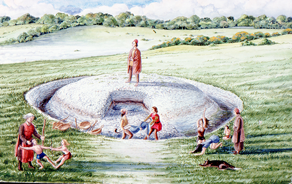
The picture in the top left shows a series of Anglo-Saxon graves under excavation. Two archaeologists are shown in the top right, in the familiar but somewhat undignified posture that is often adopted to excavate a grave with care, without standing on a significant find or on the skeleton itself.  Anglo-Saxon cemeteries usually contain many graves, laid in groups or rows. In the Ozengell Anglo-Saxon cemetery which inspired the drawings, the graves were cut into the chalk geology and had been disturbed by many centuries of ploughing over the fields.

The grave in the centre of the image is the one shown in the previous set of pictures, which was robbed soon after it was created by the excavation of a pit through the middle of the mound.  In the centre of the grave the stratigraphy of the later cutting through the grave is demonstrated, with the brown soil of the later robber cut shown sectioned within the lighter grey fill of the earlier grave fill deposit. It is through this careful unravelling of the sequence of events represented by changes in soil colour that allows us to tell the story of the robbing of the Anglo-Saxon graves.

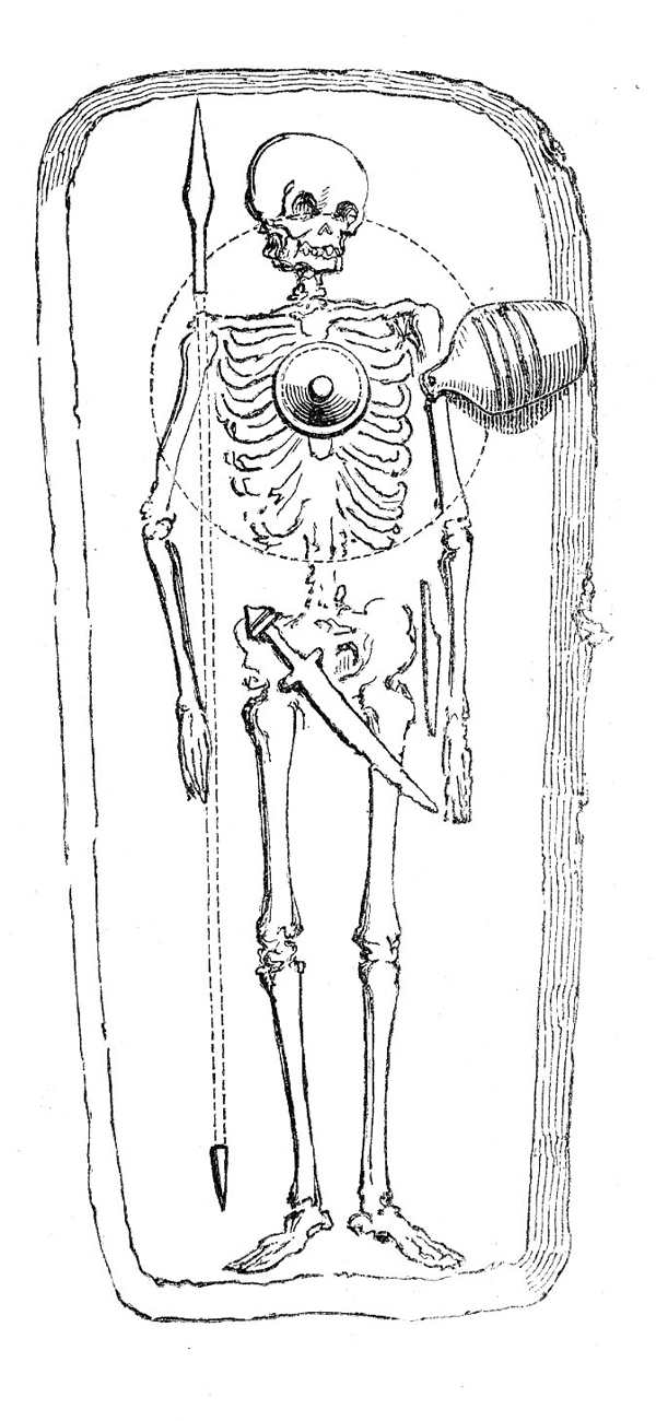
The lower right image shows the grave after the original fill has been removed, with the skeleton lying on the base. The clothes and weapons shown in the first image from yesterday’s post having been laid with the person who was buried, now only exist as corroded metal objects which have to be carefully excavated and conserved. The excavation is recorded in detail in plans and written descriptions and photographs are taken of the objects in place. Overhead shots of the whole grave are taken from the vantage point of the step ladder shown on the right.

The skeleton in the excavated grave is incomplete, the pelvis, lower spine and upper legs have been cut away by the robbers digging their pit into the middle of the mound. By carefully recording the location of the robber pits and comparing their position with the typical grave goods found in complete burials, it is possible to explore the targets of the grave robbers and the types of artefacts they may have been looking for.

The four reconstructions drawn by Len Jay describe all the processes that have occurred to give us one of our most valuable sources of evidence for the lives and habits of the Anglo-Saxon period. The first set of drawings trace the creation of the graves, their alteration by the intervention of other people  and the effect of the natural processes of decay. The second set of image shows how methods of archaeological investigation can explore all these previous events and processes and generate knowledge about life and death in the Anglo-Saxon period.

Like his colleague and friend Dr Dave Perkins, Len Jay wanted to convey to ordinary people how archaeologists carried out their work and to reconstruct the events that their discoveries were revealing. Both Dave and Len achieved this through their considerable artistic abilities.

Further reading:

The subject of grave robbing in Anglo-Saxon cemeteries in Kent is explored in detail by Dr. Alison Klevnäs in her theses titled ‘Whodunnit? Grave-robbery in early medieval northern and western Europe’ which can be downloaded as a PDF from the University of Cambridge website.  The important records of excavations in Thanet contributed evidence for this work.
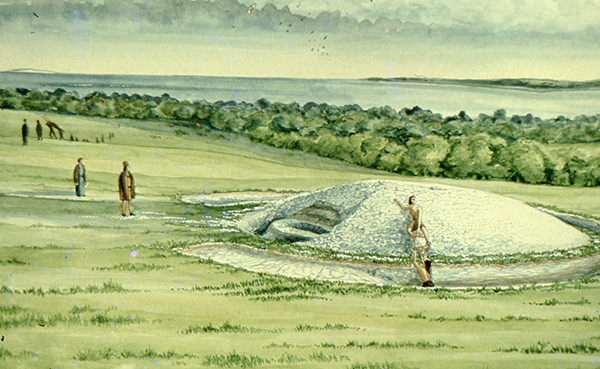
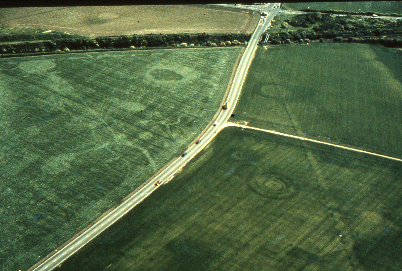
 

VM_365 Day 216 Art and Anglo-Saxon archaeology

VM 216

The image for Day 216 of the VM_365 project is drawn from our slide collection, with reproductions of a series of sketches illustrating aspects of the archaeology of the Anglo-Saxon cemeteries that are such a significant part of Thanet’s archaeological landscape.

Thanet has been lucky to have had several talented illustrators among its archaeological community.  A drawing by the Trust’s first Director Dave Perkins featured on Day 111 of the VM_365 project. Today’s images were drawn by Len Jay, a founding member of the Isle of Thanet Archaeological Unit, the predecessor of the Trust for Thanet Archaeology and the Isle of Thanet Archaeological Society. Len Jay was a trained artist and used his abilities to create imaginative illustrations of some of the significant aspects of the archaeology that the Thanet Unit became involved in.

The images in today’s post illustrate a common phenomenon encountered during the investigation of Early Anglo-Saxon cemeteries where archaeologists began to discover that they were not always the first to have dug into the graves furnished with valuable  goods such as weapons, items of jewellery, clothing and vessels in pottery and glass. It is now recognised that many early Anglo-Saxon graves that were were robbed not long after they had been created.

The upper part of the image in today’s post shows a section through a recently created grave, with its occupant dressed in typical costume and accompanied with a shield, sword and knife. In the distance the family are leaving the graveside. In the lower image, two grave robbers have excavated a pit into the centre of the mound that marks the site of the grave, piling the spoil in a heap. They too are seen making a hasty exit with the objects they have recovered.

Grave robbing at an early period has been recognised in many of the large early medieval cemeteries of northern Europe and the phenomenon extends to the cemeteries of East Kent. Although initially it may seem that the motives are relatively simple, recent study has started to consider whether the practise has more complex meanings, perhaps associated with the growth of Christianity and the ambiguous relationship of the converted population with the pagan graves of the pre-Christian era.

Len Jay used his talents as an artist to visualise the processes that were being observed in excavations and explored their meaning through his visual representation, which complemented the body of written material that was also being generated.


VM_365 Day 204 Bronze Age ‘Bugle’ fitting from Anglo Saxon grave

VM 204

Today’s VM_365 image shows a Bronze Age ‘Bugle’ fitting that was found within an Anglo-Saxon grave at  Lord of the Manor, Ramsgate in 1980.

The ‘Bugle’ fitting is named after its similarity in shape to a bugle. This particular example is a cast copper alloy tubular fitting with a hollow body and an opening on the non loop side and at either end. Fittings such as these are attributed to the Late Bronze Age and are thought to form part of a harness or part of its equipment. The most likely use for this object would be for the fastening of a leather strap although its exact function is unknown. Other suggestions for its use have included a dog whistle used in rounding up livestock.

How did it come to be in a grave over a thousand years later? It seems that at all times in history objects from the past have been seen to be interesting enough to be collected and curated as curiosities. This object may have been prized by the occupant of the grave, or have been placed there by a family member as a talisman. Alternatively it may have come to be in the grave by sheer coincidence from the soil backfilled within it.


VM_365 Day 137 Two Beaker sherds from Lord of the Manor Ramsgate

Two Beaker sherds from Lord of the Manor, Ramsgate.

Toady’s image for VM_365 Day 137 is of two admittedly small, but important pottery sherds of Beaker vessels,  like the  Grooved Ware sherd from Day 136, the two Beaker sherds were found together in the 1976 excavations at Lord of the Manor, Ramsgate.

The sherds are from Phase 2 of the development of the Lord of the Manor 1 monument, a period of Early Bronze Age activity associated with the re-use of the earliest ring ditched enclosure as a burial site. In this phase a burial was placed within a smaller ring-ditch that was cut inside the circuit of the earlier large causewayed enclosure ditch, to create a round barrow.

The smaller sherd on the left of the image is decorated with a cord impression, which would have extended over the whole body of the vessel. The second sherd on the right is decorated with a pattern in zones, created with impressions from the teeth of a comb.

The first cord impressed style is the earliest, dating between c.2300-200 BC. The second comb decorated sherd is marginally later, around 2100-1900 BC. Both sherds are made of an identical fine oxidised fabric, with a fine silty fabric matrix and fine crushed pot grog tempering. Both have a similar neat, finely executed  decoration and so can reasonably be thought of as contemporary vessels.

Both sherds were found in a small pit, located  outside the ditch enclosing the central burial. The two sherds indicate a date between c.2100-2000 BC for the feature, although this has not yet been confirmed by Carbon14 dating.

Once again today’s VM_365 image and information on the pottery has been provided by ceramic specialist Nigel Macpherson-Grant.

VM_365 Day 136 Ramsgate Late Neolithic Grooved Ware sherd

Late Neolithic Grooved Ware sherd

Today’s Image for VM_365 is of a small scrap of Late Neolithic pottery from 1976 excavation of the ring ditch of one of the ceremonial enclosures at Lord of the Manor, Ramsgate.

The sherd is a rim fragment from a tub-shaped vessel with a small-diameter. The exterior of the rim is decorated with incised grooves, the inner edge of the rim has a distinctive bevel, similar to the rims of other examples of this type of pottery. The typical decoration of the sherd with a pattern of grooves in the surface, provides the name that has been given to this ceramic tradition; Grooved Ware.

Before flat based grooved ware vessels began to manufactured, all Early and Middle Neolithic pottery in this country was made with round bases. Grooved Ware is believed to have been first used in the Orkneys, spreading southward across Britain and seems to represent the only truly ‘homegrown’ tradition in the entire history of British ceramics.

The style of decoration on this sherd, coupled with the beveled rim,  places the sherd into the Durrington Walls style, which was current during the main building phases at Stonehenge and is dated to c.2800-2300 BC

To date the tiny sherd pictured here seems to the best example of Grooved Ware archaeologists have recovered on the Isle of Thanet. Although it is small, the sherd  is a valuable hint that there may be more evidence of this important period of settlement to discover in the future.

The image and information for today’s VM_365 post were kindly provided by a guest curator, ceramic specialist Mr Nigel Macpherson-Grant

In 2007 a group of potters experimented with manufacturing Grooved Ware vessels, follow this link to the Prehistoric Ceramics Research Group website article on the process.