Category Archives: Ramsgate

VM_365 Day 348 Philpott Mineral Water Company, Ramsgate

VM 348Today’s image for Day 348 of the VM_365 project shows another early 20th century glass soft drink bottle from the Trust’s collection from a local manufacturer.

The bottle is made of olive green glass and was found with its screw cap stopper still intact. The roundel reads ‘Philpott Ramsgate 1911’ with the company logo in the centre.

This bottle was produced for the Philpotts Mineral Water Company who were established in 1850 and operated from 1A Cavendish Street, Ramsgate. Presumably the company drew their water from a draw well, noted on the 19th century 1:500 town map of Ramsgate, and aerated it on site in a similar way to Reeve & Co. Ltd who featured in yesterday’s post for Day 347 of the VM_365 project.

In 1878, Philpotts opened a shop at 16 High Street from which they sold their products.  The census for 1881 indicates that Stephen Philpott, owner of the mineral water company employed 4 men and a boy.  The shop closed in 1905 and the company itself ceased to trade in 1920 when it was taken over by the Ozonic Mineral Water Company, the soft drinks arm of the Tomson and Wotton Brewery.


VM_365 Day 344 Ramsgate’s Air Raid Tunnels

VM 344

Today’s image for Day 344 of the VM_365 project shows a section of the World War II air raid tunnel system which was constructed under the town of Ramsgate in 1939.

The tunnel system exploited both the natural topography and geology of the town. The contours of the town, rise in all directions from the central valley around which the town developed from the 16th and 17th century onwards. The tunnel system follows this rise in the natural topography and encompassed the town, albeit below ground. The tunnels were cut into the chalk bedrock and chalk, if it is cut correctly, stabilises naturally and is self supporting, making it ideal for a deep underground system.  In the picture above you can see the seams of flint that occur naturally in the chalk.

The tunnels were constructed beneath the road system of the town which avoided legal issues that might occur had the system extended below private properties. Most of the tunnels were left unlined as the average depth was approximately 21 metres below ground level which was considered safe to survive a direct hit from bombs on the ground above.

Ramsgate Tunnels are now open for guided public tours at weekends and during the week and are well worth a visit as the tour also covers aspects of the history of the Victorian railway tunnel which played it part in the World War II tunnels system. Advance booking is recommended and there is a free exhibition on Ramsgate’s part in Operation Dynamo, the Evacuation of Dunkirk in 1940.


VM_365 Day 343 Sailor’s Welfare, Ramsgate Harbour

VM 343
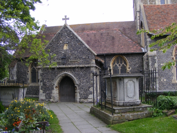
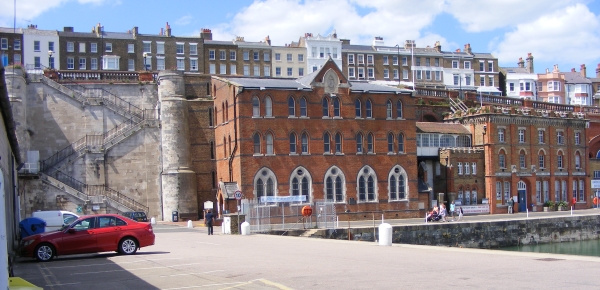
Today’s image for Day 343 of the VM_365 project, another in the Our Thanet series, shows a group of 19th century structures at Ramsgate Harbour.  At the left side of the image is Jacob’s Ladder,  the Sailor’s Church is in the centre of the image and the oddlynamed Smack Boy’s Home is on the right side.

Jacob’s Ladder is a flight of ashlar steps that were constructed in 1826, replacing an earlier set of wooden steps that were built in the further to the east in the mid 18th century. The steps were designed by the architect John Shaw an the construction of Jacob’s Ladder in stone  undoubtedly made it easier to access the harbour safely from the cliff top.

The Sailor’s Church and Sailor’s Home was founded with the support of the vicar of Christ Church, which was located  in Vale Square nearby.  In 1863 50 fishing smacks  were registered at Ramsgate harbour and by 1906 there were 168 registered smacks operating from Ramsgate. The crews of the fishing smacks were made up of a skipper with four other crew members, who were often young boys many of whom had come from the workhouse, some of those apprenticed to the vessels were as young as 10 years old. The young crew members became known as smack boys.

Work on the fishing vessels was hard and dangerous work, especially for the smack boys and a number of the vicars of nearby Christ Churchrecognised that the men and boys who crewed the fishing smacks and other vessels sailing from Ramsgate not only needed spiritual guidance but also physical help.

When the Sailor’s Church was eventually opened  in 1878 the church was located on the ground floor and a dormitory above was provided shelter and some comfort to the young apprentices when they came ashore.

As a result of pressure put on the Board of Trade by Reverend Brenan of Christ Church  a three storey purpose built  Smack Boys’ Home was opened in a building next  to the Sailor’s Church in 1881. Ramsgate seems to be unique among Britain’s fishing ports in providing a purpose built refuge for the Smack Boys.

In later years the Smack Boys home was used to house sailors rescued from shipwrecks, which often occurred off the Goodwin Sands. During the First World War over 3000 men were given food, clothing and shelter as well as medical treatment in the home.

It is still possible to visit these unique buildings, Jacob’s Ladder and the Sailor’s Church are both accessible to the public and the Sailor’s Church continues to hold services and also offers teas and coffees during peak seasons.
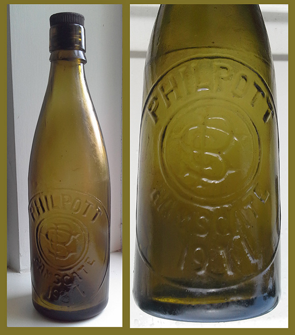

VM_365 Day 342 Powder Magazine, Ramsgate Harbour

VM 342-1

Today’s image for Day 342 of the VM_365 project shows an oft overlooked stone building, constructed in 1828 to a design by the architect John Shaw and located on the west side of Ramsgate Royal Harbour.

Constructed of Ashlar blocks, with a slate roof, this structure was a purpose built Powder Magazine erected on the south west end of the harbour cross wall. The Powder Magazine had two doors at either end and was designed as a safety measure to hold up to 600 barrels of gunpowder from the various ships that were at anchor in the harbour.

With such combustible contents, powder magazines were designed with thick walls and thin roofs so that in the event of an accidental explosion the blast would be forced upwards through the roof rather than outwards through the walls. This would hopefully minimize the effects of the explosion; including the risk of spreading fires, on the people, wooden ships and other property in the harbour.


VM_365 Day 341 Unique vantage points and prehistoric sites

VM_341

The image for Day 341 is another in the series of Our Thanet posts, showing locations that play an important part in the exploration and appreciation of Thanet’s heritage.

The image shows a view taken facing south and south west from a downland hill top at Lord of the Manor, Ramsgate when part of the ring ditch associated with a Bronze Age round barrow was partly exposed in a training excavation in 2013.

Although it is partly obscured by trees and buildings that have grown up since a railway cutting was pushed through the chalk hillside in 1847, it is still possible to see the vista across the low lying bay that could be seen from the vantage point of the raised central platform enclosed by the ring ditch. From the centre of the mound the horizon falls away in a wide sweep from the north east to the south, giving a view across Pegwell Bay.

It can be no coincidence that a location commanding such an impressive view was chosen for the location of  such a major monument in the Bronze Age. Everywhere on Thanet where such unique points which command similar impressive views over the landscape can be found, there are also concentrations of prehistoric monuments, some unusually large in size or very complex such as the Lord of the Manor 1 multi phase monument which featured all the way back on Day 21 of the VM_365 project. Artistic reconstructions of the development of the landscape over time featured in an earlier series of VM_365 posts starting on Day 265.

This unique landscape is increasingly under pressure from development and it may soon not be possible to see what the prehistoric inhabitants of the Isle could see from the vantage points of the downland hilltops.

VM_365 Day 330 Earliest standing remains of the hamlet of Hereson, Ramsgate

VM 330
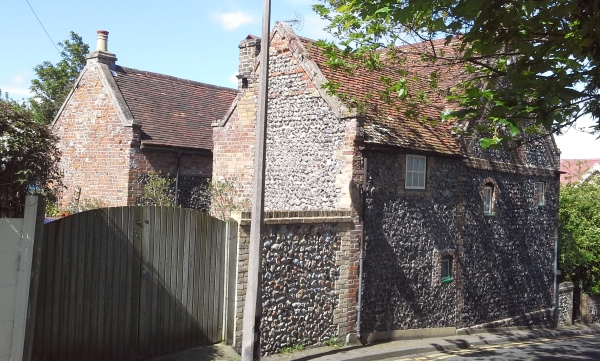
Today’s image for Day 330 of the VM_365 project shows a pair of cottages that are located in the old Thanet hamlet of Hereson, near Ramsgate.

In the medieval period the main settlement at Ramsgate was the village focussed around the parish church of St Laurence the Martyr. The town of Ramsgate developed from a fishing village in the parish of St Lawrence to a coastal port in its own right from the 16th and 17th centuries onwards. The earliest buildings associated with the develoment of the town of Ramsgate are generally foccussed along the High Street, Ramsgate and High Street, St Lawrence which follows the route from the harbour to the parish church. A grade II listed cottage with Flemish gables, one of the earliest buildings in Ramsgate, featured on Day 6 of the VM_365 project.

The medieval village of St Lawrence was surrounded by other clusters of settements within the parish, including the hamlets of Hollicondane, Hereson, Chilton, Pegwell, Haine, which were generally located close to major farms.

The pair of cottages in today’s image are located on Honeysuckle Road. These buildings are the oldest remnants of the hamlet of Hereson, which was located less than 0.5km east of the town boundary of Ramsgate.  The cottages, with kneelered gables, were originally constructed in locally sourced flint and brick in the 1600’s. The structures were altered in the 19th century.

The urbanisation of Ramsgate in the 18th and 19th and early 20th centuries expanded the developed areas of the town out from the main route to the parish church with a mixture of grand houses and mansion dwellings for the upper and middle classes as well as buildings with industries and public services essential to a growing port trade and seaside destination.   Breweries, public houses, maltings, flour mills, water towers and other public amenities and transport links began to extend outside the early focus of the port. Ramsgate began to encroach on the agricultural land that surrounded it absorbing the smaller hamlets into the urban sprawl.

However, with careful attention to archaeology of the buildings in the town, the hidden hamlets of Thanet can still be traced and many interesting and important buildings survive in the modern town.


VM_365 Day 328 South Porch, church of St Laurence, Ramsgate

VM 328

Today’s image for Day 328 of the VM_365 project shows the south porch of the parish church of St Laurence the Martyr, Ramsgate which previously featured on Day 326 of the VM_365 project.

The south porch was constructed in the 15th century around the same time as the upper stage of the tower. The 15th century porch which incorporates a lamp bracket, conceals the original Norman rectangular doorway which is visible inside along with the water stoup.

In front of the south porch you can see two of a number of railed tomb monuments which have been erected in the churchyard. The one to the left of the porch dates to the mid 19th century and the one to the right is of early 19th century date providing another illustration of the complex archaeology of church buildings and their associated yards which were so central to the Christian communities of the early medieval to modern period.


VM_365 Day 326 The parish church of St Laurence, Ramsgate

VM 326

Today’s image for Day 326 of the VM_365 project shows the parish church of St Laurence, Ramsgate viewed from the western end.

A church at St Laurence was founded in 1062 and the church  is mentioned in Thorne’s Chronicle of St Augustine’s Abbey when it was given to the Abbey in 1124. The church like St John’s, Margate and St Peter’s, Broadstairs was one of the chapels to the Mother church at Minster which featured on Day 322 of the VM_365 project until it became a parish church in its own right in 1275.

The church followed the same pattern as the churches of St John and St Peter, being enlarged in the late 12th century and the naves, arcades and the tower; which is constructed of Kent ragstone and flint with Caen stone dressings, are of this phase.

The upper part of the tower with its crenellations  is clearly different from the lower stages and dates to around the 15th century along with the construction of the south porch.

The churchyard contains a number of tombstones dating to the early 18th century, mainly located within two or three metres of the northern side of the church, that are decorated with crossed bones and winged cherub’s heads.

References/Further Reading

Berg, M. and Jones, H.  2009. Norman Churches in the Canterbury Diocese. The History Press.

Historic England 2015. The National Heritage List for Britain: The Church of St Laurence. List entry no. 1336662. http://list.historicengland.org.uk/resultsingle.aspx?uid=1336662


VM_365 Day 301 Dumpton archive confirms Roman building

VM 301

The image for Day 301 of the VM_365 project is taken from a digitised colour slide that was taken at the site at Dumpton near Broadstairs which was excavated by Joe Coy in the 1960’s. The archive from this excavation has been featured in a series of VM_365 posts, which have been looking at the detail of the finds to try to understand the significance of this unpublished site. Although the archive box for this site is labelled 1965, it appears that the dig began in 1961, when the slide archive indicates that this image was taken. The labelling of individual pottery sherds in the archive also indicates that some were recovered in a dig on the site in 1961. The picture is very important because it proves that one of the major features investigated on the site was a Roman structure, partly built in a distinctive local type of building stone used extensively in the Roman period.

Several strands of evidence have led to previous suggestions that a structure  from the Roman period was present on the site. The earliest evidence was given in Reverend John Lewis’s History of the Isle of Thanet, where it was noted that Roman coins had been found in the Dumpton area. At the time of writing in 1736, Lewis reported that a Roman wall had relatively recently been observed, but had fallen into the sea following a cliff fall. An excavation carried out by Howard Hurd on the cliff tops when new roads were being laid out on the sea front also recorded ditches and enclosures, which were predominantly of Iron Age date. A dig by the Trust for Thanet Archaeology at site near to Joe Coy’s excavation that re-examined part of Hurd’s published site, recognised that the period of occupation on the site extended well into the Roman period, much later than Hurd had suggested. One significant find in the Trust’s excavation was of a small number of fragments of distinctive Roman roof tile forms, including both Tegula and Imbrex. this evidence all pointed to the previously unrecognised presence of a building on the southern slopes of the dry valley at Dumpton gap.

Recent evidence from excavations on major Roman buildings in Thanet have suggested that all were founded on substantial Iron Age settlement sites. It is likely that prosperous Iron Age farming communities in Thanet quite quickly adopted Roman building methods and began to use imported Roman pottery alongside vessels that continued to be made in traditional pre-Roman forms and in local fabrics exhibiting various degrees of influence from the material imported from the Romanised continent.

Sadly many of Thanet’s Roman buildings have been so heavily damaged by ploughing and stone robbing that little remains of their structure but the lowest courses of walls or those lining deep recessed parts of the structures like cellars and sunken floor levels. However the presence of structured remnant of walls, built of the distinctive rounded flint cobbles is paralleled on so many sites that their presence in this image, taken with the range of finds that were associated with the excavation site, are strong evidence that another Roman building was present on the southern side of the dry valley that leads to Dumpton Gap. The topographic location of the structure is also similar to the buildings excavated at Stone Road, Broadstairs and the Abbey Farm Villa at Minster.

In today’s VM_365 image, the presence of a building is confirmed by the presence of the  line of rounded flint cobble wall which is visible running from left to right in the foreground of the image. Although the pictures have not yet been reconciled fully with the plan that was contained in the archive, it appears that the wall is part of the southern side of a rectangular  flint lined cellar, which once formed part of the structure of a building. There are striking parallels with the image and the pictures of the surviving structures found further to the north at Stone Road and on the cliff top on the northern side of Viking Bay at Fort House, Broadstairs, which have appeared in previous VM_365 posts.

It is likely that further research on the archive and re-examination of the results of the other digs in the area will bring more evidence confirming the importance of this site which spans the Iron Age and earlier part of the Roman period.


VM_365 Day 294 Iron Age and Roman pottery sherds from 1964 Dumpton excavation Archive

VM 294

The image for today’s post on Day 294 of the VM_365 project shows the contents of some of the paper bags, stored in an archive box from an excavation carried out by Joe Coy with the Thanet Excavation Group at Dumpton, between Broadstairs and Ramsgate in 1964.

To understand how important the information contained in the archive is, we need to carefully examine how and why each item has been stored and labelled. In the image above the sherds are laid out on the paper shop bags they were stored in so that they can be assessed in more detail. Later they will need to be catalogued and put into plastic bags which will help to ensure their safe storage in the long term

All but two of the bags in the 1964 excavation box contain pottery sherds. The sherds have generally been marked with a site code and feature number, which we now know corresponds with feature numbers on the sketch plan in the box.

There seems to be no corresponding finds list, description of the pottery or dating for the items in the archive box, so each pottery sherd  may have to be re-examined to understand the date range of the features fully.

However even a casual examination of the material reveals the span of the dates covered by the sherds, apparently a classic assemblage spanning the Late Iron Age and Early Roman period. Many of the pottery sherds are comparable with typical vessel types from other sites the local area, which have featured in earlier VM_365 posts.

The site excavated by Joe Coy and the Thanet Excavation Group in 1964 is very close to a large site excavated at Dumpton Gap by Howard Hurd, one of Thanet’s archaeological pioneers. Although Hurd emphasised the Iron Age aspects of his site, described by him as the remains of ‘a Late Celtic Village’, later excavations suggested that there was a more significant Roman element to the settlement than was previously thought. As we start to understand the 1964 archive, it looks likely that this will make a significant contribution to understanding that Roman settlement phase here.

The analysis will continue in subsequent posts.