Category Archives: Medieval

VM_365 Day 321 The parish church of St Nicholas, St Nicholas-at-Wade

VM 321
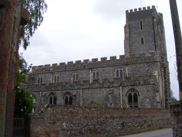
Today’s image for Day 321 of the VM_365 project shows another of our standing archaeological remain, this time the church of St Nicholas, St Nicholas-at-Wade, near Birchington.  The earliest church at St Nicholas was built in the late 11th century and parts of it survive in the lower portions of the west wall of the nave. The original church was constructed of large flints and sandstone from the Thanet Beds.

By the mid 12th century a south aisle was added to the nave and the arcade still survives. A north aisle may have been built at the same time but was replaced in the early to mid 14th century.

The church was a Chapel to Reculver until the end of the 13th century along with Sarre and Shuart. In the late 12th or early 13th century, a new east end was built with a new long chancel and two smaller chapels on either side. New windows were inserted into the chapels and the chancel in the late 13th to early 14th century; traces of the original east lancet windows are still visible in the walls of the east chapels where they are cut through by later windows.

The church was enlarged in the mid 14th century after it became a parish church in its own right in 1310 and as a result of an increase in the local population. Major rebuilding of the nave was carried out with a completely new north aisle and arcade constructed in Ragstone and Caenstone. A new tower was also built at the same time and a new south porch added sometime after. In the late 15th century, a new clerestory to the nave was built and the top of the tower, the aisles and porch were crenellated with knapped flint parapets.

In the mid to late 18th century, the south chapel was used as the parish school and its brick chimney stack is still visible. The chancel was repaired, the east wall rebuilt and the nave restored in 1875 and 1876.

While at face value parish churches may seem to be a steady and unchanging part of the fabric of Thanet’s village landscapes, they represent buildings that were constructed from the late Anglo Saxon period and continues to evolve as architecture until the present day. The story of these buildings is preserved in their visible structure if we take the time to read them properly.


VM_365 Day 320 The Tudor House, Margate

VM 320

Today’s image for Day 320 of the VM_365 project shows another of Thanet’s earliest standing buildings, the Tudor House at Margate. The house is of timber framed transitional type; a cross between the open hall house of the medieval period and the early modern house. The transitional house retained the high and low end arrangement of rooms that were seperated either side of the open hall  during the medieval period but did not have the open hall and was instead storied along thefull length of the first floor.

This high status timber framed building dates to the period around 1525-1550.  It was originally built for a wealthy household, possibly a farmer with additional sources of income and was heavily restored close to its original form in 1950 after having previously being subdivided into cottages sometime in the early to mid 19th century.

The Tudor house has a continuous jetty along the first floor and is  supported at the corners by dragon posts. It also has a jettied roof  supported internally by crown posts. In the western end of the building, where the service rooms were located, is a chalk and flint constructed cellar. The house was heated by two brick built chimneys.

The original windows, some of projecting oriel type, were glazed throughout, a conspicuous sign of the wealth of the owners of the building. Projecting Oriel windows can be seen on the ground floor in the image above.

Sometime in the 17th century an extension was added to the eastern end of the building to accomodate a larger stairway and the parlour ceiling was lavishly decorated with a plaster ceiling embellished with Tudor roses, grapevines and other motifs common at the time.

A 17th century malt house which featured on Day 67 of the VM_365 project was constructed to the rear of the building and its remains can still partly be seen  today.

The Tudor House is open to view by the public and is well worth a visit.

Reference/Further reading

Twyman, M and Beeching, A. 2003. The Old Tudor House at Margate. Margate Historical Society Local History Study Document Number One. Revised 2006.

Austin, R. 2014. Tudor House, Margate. In Canterbury’s Archaeology 2012-2013. Annual Review of Canterbury Archaeological Trust. pp 21-22.

VM_365 Day 319 Dent-de-Lion Gatehouse

VM 319
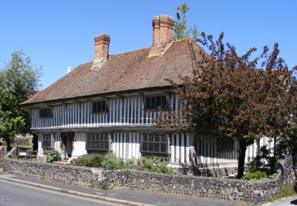
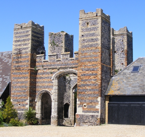
The image for Day 319 of the VM_365 project shows Dent-de-Lion gatehouse, Garlinge. The Gatehouse was constructed in the early 15th century  forming the main entrance into the courtyard of a now demolished fortified house which stood to the north.

Fortified houses were constructed mainly in the 15th and 16th centuries and belonged to individuals or families of wealth and high status. Dent-de-Lion was constructed for the Daundelyon family after whom it is named, although it later passed into the Pettit family by marriage.

The Gatehouse was used to approach the main house from the south, the same direction as the image  above. The gatehouse is east west aligned, rectangular in shape and constructed of flint and yellow and red brick with ashlar dressings with a tall arched carriage entrance in the centre and on the western side a smaller archway for pedestrian access. There are four square corner towers each having gunloops,  arrow slits and staircases with access to the roof.  There is also a carved stone shield over the carriage arch with the Daundelyon family coat of arms.

As there are fewer than 200 identified examples of medieval fortified houses in the country,  Dent-de-Lion Gatehouse is considered to be of national importance and is both a Scheduled Ancient Monument and a Grade II* Listed Building.

Further reading/references

Woodruff, C. E. 1902. Dent-de-Lion Gatehouse, Margate with a pedigree of the family of Pettit. Archaeologia Cantiana 5, 57-63.

Historic England Scheduled Monument entry: http://list.historicengland.org.uk/resultsingle.aspx?uid=1018875

Historic England Listed Building entry: http://list.historicengland.org.uk/resultsingle.aspx?uid=1341531

VM_365 Day 318 Jug from Medieval Farmer’s Table

VM 318
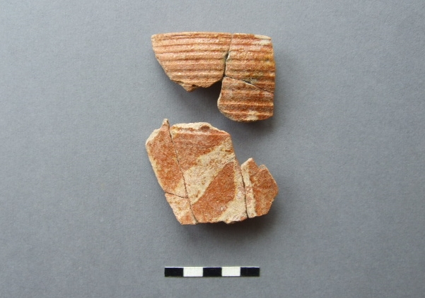
The image for Day 318 of the VM365 project shows sherd fragments from a medieval tableware jug found in 1979 in an excavation at Netherhale Farm, Birchington.

The late David Perkins conducted a trial excavation  to test the cropmarks of a double ditched enclosure on land between Birchington and St.Nicholas-at-Wade. The excavation revealed a Mid-Late Bronze Age farmstead enclosure (c.1350-1150 BC) underlying a medieval farmstead  enclosed with a ditch. This site could possibly be the medieval forerunner of the modern Netherhale Farm which stands  just to the north of the site.

The cropmarks lie on a very slight knoll and presumably was chosen in both periods of settlement for its well-drained position. Apart from some deeply cut ditches and pits, the ditches and the settlement they enclose have been heavily plough-reduced.

The Medieval phase of occupation produced the fragments from the tableware jug shown above which are from a fairly tall ovoid-bodied jug.  The rim is shown in the upper part of the image, with a horizontally incised neck below and the upper shoulder and body has been painted in white slip with vertical and diagonal stripes under a clear orange (iron) glaze over.

The jug was made at the Tyler Hill potteries near Canterbury and the form, type of decoration and the firing qualities date its manufacture to between c.1250-1325 AD,  a period known in art-historical terms as the ‘High Medieval’ .

Although this vessel is perhaps not as constructively creative as the Scarborough Ware ‘knight’ Jug or the south-west French polychrome-painted jug which were contemporary with this example,  its striking colours and design would have made a handsome addition to the farmstead’s dinner table.

VM_365 Day 317 Church of St Mary Magdalene, Monkton

VM 317

Today’s image for Day 317 of the VM_365 project shows the parish church of St Mary Magdalene, Monkton which is located at the western end of Monkton just off Monkton Street. The church is mainly built from flint and Thanet Beds sandstone with Caen and Ragstone used for the quoins.

The church of St Mary Magdalene was located within the Manor of Monkton which was given to Christ Church Priory, Canterbury in the late Anglo Saxon period. Two churches were documented in the Domesday Book of 1086 as being part of the Manor of Monkton, one of these probably stood on the site of the present church, which was constructed in the late 11th to early 12th century; the other is probably its dependent church located at Woodchurch, Acol. The church remained in the possessions of the monks of Christchurch until the dissolution.

The tower was constructed in the late 12th or early 13th century, around the same time that the church nave was increased in size by constructing a new northern aisle along the entire length of the north side.

In the late 14th or early 15th century major alterations were carried out to the church reducing it in size and adding new windows and roofs. These alterations may have been undertaken as a result of the reduction in population of the inhabitants of the area because of the Black Death. You can see an example of these alterations in the image above as a series of three of the five blocked arches along the northern side of the church, evidence of the demolition of the late 12th century extension to the nave.

The church was restored in the mid 19th century by C. A. Beazley; the chancel floor was raised, a new vestry constructed under the tower and the north porch was rebuilt and outer doors were inserted. Most of the interior fittings of the church date to this time.

References/Further Reading

Hasted, E. 1800.  The History and Topographical Survey of the County of Kent: Volume 10. Bristow: Canterbury pp. 253-264.

Tatton-Brown, T, 1993. St Magdalene Church, Monkton. Canterbury Diocese: Historical and Archaeological Survey. Kent  Archaeological Society.


VM_365 Day 310 Early Medieval foundations at St Mildred’s Priory, Minster

VM 310

Today’s image for Day 310 of the VM_365 project continues  our theme of keyhole excavations and the important archaeological information that can be gleaned from them. The image shows two views of the remains of a rammed chalk foundation that was recorded during the work in 2010 to re-lay drains at St Mildred’s Priory, Minster. The Priory is located on the the eastern edge of the village of Minster, on low lying lands overlooking the marshland in the former Wantsum Channel.

The standing buildings at St Mildred’s Priory, which has also been known as Minster Abbey and St Mildred’s Abbey, date from the  11th and 12th centuries and were constructed as a monastic grange by the Benedictine Monks of St Augustine’s Abbey Canterbury after the land was granted to them by King Canute.

The site of the monastic grange had previously been occupied by a nunnery, established at Minster by Domneva, a niece of  King Egbert of Kent in the 7th century. Domneva’s daughter later became known as St Mildred, after whom the Abbey was later named. The early nunnery was reported to have been destroyed during the Viking incursions in the 9th century after which the land became a farm, or grange, for St. Augustine’s Abbey.

The buildings of the monastic grange were renewed and altered in the early 15th century and the standing remains include herringbone walling, Norman doorways and windows and a medieval brewhouse. Following the Dissolution of the Monasteries in the mid 16th century, the grange passed into private hands and the former monastic grange has been used as a Benedictine nunnery since 1937.

In 2010 work was carried out to re-lay the 19th or early 20th century drainage pipes located on the western side of the northwestern range of buildings known as the Saxon Wing. This involved digging out the backfill of the old pipe trenches, exposing the existing pipes and then relaying them with modern pipes.

In one of the trenches a demolished wall or wall foundation of rammed chalk was exposed, forming a corner of a structure with a different orientation to the standing buildings of the former monastic grange.  In the picture on the left the foundations are visible below the original pipes and in the image on the right the foundations can be seen after the original pipes have been removed.  The interior of the wall appeared to have originally been faced with pieces of sandstone. Crushed fragments of sandstone found in the demolition deposit above the chalk foundation suggest that the upper part of structure may have been formed of sandstone blocks.

Two fresh sherds of North Kent shell filled sandy ware pottery from a sagging base cooking pot, dating to 1150-1225 AD, were found in a deposit built up against the outer face of the wall suggesting the structure dated from this period or earlier. The building materials associated with this wall foundation are similar to those of the west wing, part of which was constructed before 1085. In the 12th century the grange was enlarged and the west block was converted into kitchens and living quarters.

It is not clear whether the structure exposed in the pipe trenches relates to a new structure, built when the west block was converted, or whether it was a structure demolished to make way for the 12th century rebuilding. However this small keyhole excavation has indicated the location of the footprint of an early structure associated with this important medieval building and may provide a guide to future investigations when a more extensive investigation of the structure  may be possible.

VM_365 Day 278 Medieval knife

VM 278
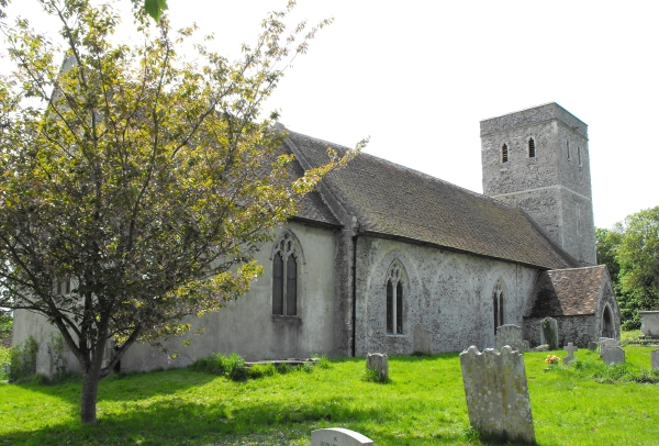
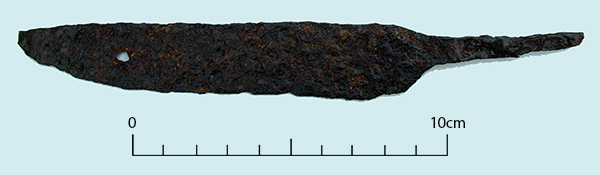
The image for Day 278 of the VM_365 project is of a medieval iron knife found in a layer of medieval occupation debris including 13th to 14th century pottery sherds found in investigations carried out during road improvements between St Nicholas at Wade and Monkton in Thanet between 1990 and 1991.

The knife has a whittle tang which means that a wooden handle would have been knocked over the tang, rather than having a two piece handle rivetted onto a wide tang, an innovation that became more popular from the mid medieval period onwards.

This was an all purpose knife that could be used for eating, working and for defence and was a development from the Anglo Saxon scramasax, probably carried in a leather sheath at the waist.


VM_365 Day 270 Medieval purse frame

VM 270
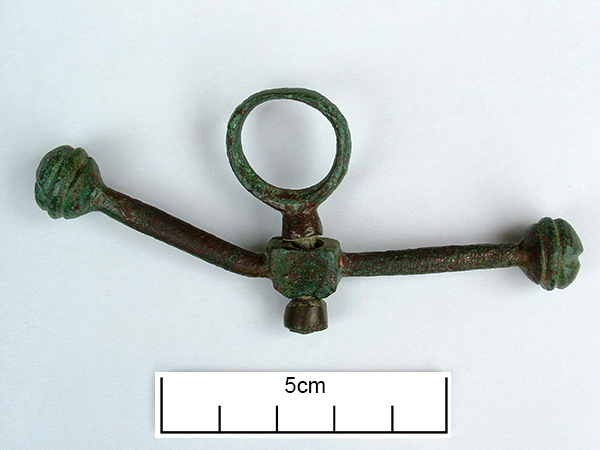
Today’s image for Day 270 of the VM_365 project shows a medieval copper alloy purse frame dating from the period 1474-1550 which spans the reigns of Edward IV, Edward V and Richard III. The purse frame was found in the excavation of a medieval well at Little Cliffsend Farm that was previously featured on VM_365 Day 251.

The metal frame would have supported a fabric or leather purse suspended from the bar, one of the arms of which is now bent. The purse and frame would then have been suspended from a belt or other strap by the central, swivelling, suspension loop.

We can only speculate as to whether this was just an item thrown away with other waste into the well, or whether it was an unfortunate loss by someone leaning over the edge to draw water. Either way it seems that the purse was empty when it ended up in the well.

VM_365 Day 260 Cropmark of Medieval Post-Mill at Sarre

VM 260

Today’s image for Day 260 of the VM_365 project shows cropmarks  at Sarre recorded during an aerial reconnaissance flight by the Trust for Thanet Archaeology in 1990.

The cropmarks, located to the east of the existing Sarre Mill, show an Anglo Saxon cemetery in the north east quadrant of the picture and a medieval post-mill foundation showing as a ring ditch with a cross in the centre in the south west quadrant.

Evaluation trenching by the Trust in 1990 sampled a number of the Anglo Saxon graves which have previously featured in VM_365 posts and also sampled the cropmark of the post-mill.

The Sarre post-mill is of similar form to the post-mill that was excavated at St Peters, Broadstairs. The ring ditch and cross trench at Sarre contained pottery in 13th and 14th century fabrics indicating that a windmill has stood at Sarre from at least the 13th century.

VM_365 Day 259 Medieval Post Mill at St Peters, Broadstairs

VM_259

Today’s image for Day 259 of the VM_365 project shows the foundations of a medieval post mill which was excavated prior to the construction of the ASDA superstore at St Peters, Broadstairs in 1999.

The Post Mill is the earliest type of Windmill in Europe. The whole structure of the mill, its sails and internal machinery were supported on a central pillar which allowed it to be turned to bring the sails into the prevailing wind. The  central pillar formed part of a trestle structure.  A cross shaped foundation, called a Cross tree, was laid in a trench and supported four angled braces called quarter bars, that propped up the central pillar. The trestle may have been buried in a mound of earth.  A tail pole was used to turn the sails into the wind.

The foundations of the trestle, visible as a cross, are shown in the centre of the ring ditch. In the image above, a number of segments have been excavated through the circuit of the ring ditch which surrounded the mill in which the tail pole would have been swung to turn the mill toward the wind.