Category Archives: Iron Age

VM_365 Day 305 Filling in the blanks……

VM 305
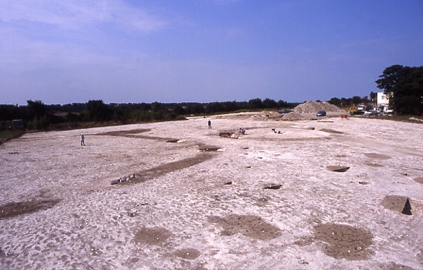
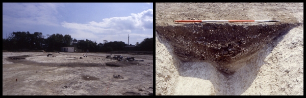
Today’s image shows two views of a very small excavation carried out during the construction of a garage at North Foreland Road, Broadstairs in 2004.

The North Foreland landscape is particularly rich in archaeological remains. Cropmarks identified by aerial photography show an ancient trackway along the edge of the hillside. A large open area excavation carried out in recent years on the previously undeveloped playing fields of the former St Stephen’s College confirmed that the area had been occupied at least since the Early Bronze with the construction of burial mounds and during the Iron Age when a settlement was established which included a Middle Iron Age enclosure and significant numbers of postholes and large storage pits.

The area to the east of the site was developed for housing from the late 19th century onwards and although occasional archaeological discoveries were reported these were generally made before a time when the significance of the area was understood and archaeological features were often not recorded in detail or at all. So how do we fill in the blanks in an area that has already been developed?

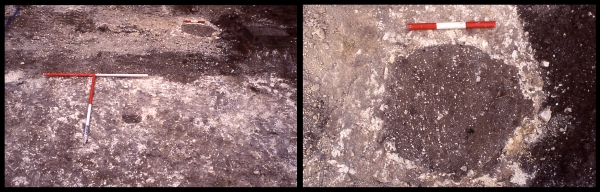
As a local archaeological organisation, we are often involved in very small scale construction projects such as, for example, a small garage for a house along North Foreland Road, not far from the St Stephen’s site shown in the images above. The excavations only covered an area of approximatley 6 metres by 5 metres and the ground had already been disturbed by modern drainage which is visible as a linear stripe of dark soil visible above the T shaped scale in the picture on the right. However, eight pits and postholes containing Iron Age pottery still survived suggesting that the Iron Age settlement excavated at the St Stephen College site was much more extensive. An example of one of the pits is shown in the picture on the right.

Through the keyhole of small investigations such as these we can fill in the missing detail and gradually build up a bigger picture of the landscape.

VM_365 Day 303 Iron Age polychrome decorated pottery from Dumpton Gap

VM 303
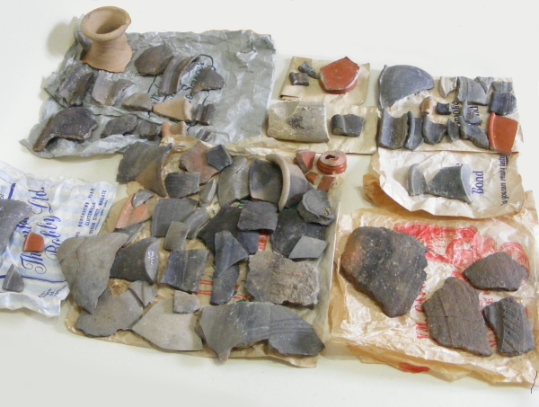
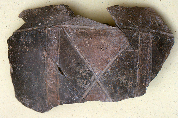
Today’s image for Day 303 of the VM_365 project shows a number of joining sherds from the upper part of an Iron Age  polychrome decorated pottery vessel, which was found in an excavation at Dumpton Gap in the 1960’s.

The image of these joining decorated sherds was digitised from a slide taken by Joe Coy, who directed excavations at the site at Dumpton. The slide is one of a small group in the same archive as the box of finds that we explored in previous posts from Day 292  to Day 301 of the VM_365 project.

The post for VM_365 Day 302 looked at the monochrome surface finishes on two Iron Age sherds, one caused by natural staining, the other by deliberate application of a black carbon pigment.  The vessel shown today exhibits a more complex decorative finish in a rectilinear and geometric style, similar to the Halstatt inspired scheme on the deliberately decorated sherd dating from the Early to Mid Iron Age. The pot is made of a dark grey fabric, whose surface is decorated  using red Iron Oxide pigment  to fill in some of the triangles and stripes that have been scored in a regular geometric pattern over the surface of the clay.

The use of the red pigment to create regular rectilinear geometric decoration is similar to that of another Early to Middle Iron Age sherd from Sarre which featured on Day 198 of the VM_365 project.

Another vessel from Margate, decorated with fields of red iron oxide pigment, was featured on Day 226 of the VM_365 project, although the decorative finish on that vessel is typical of the later curvilinear La Tène decorative style.

VM_365 Day 302 A tale of two sherds

VM 302
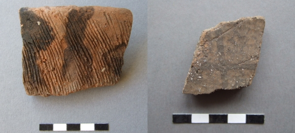
Today’s image for Day 302 of the VM_365 project is of two Iron Age pottery sherds, both from a similar archaeological period and from the same site near Broadstairs. Both sherds seem to exhibit an apparent surface decoration. However, the origin of the patterns on the surface of each sherd is quite different.

The sherd on the left is from the rim of a simple open-form bowl. The fabric is flint-tempered and the surface has been decorated with a comb, it is datable to between c.500-350 BC. But what are the black streaks on the surface? The sherd has been washed when it was brought from the site but the black colouring survived intact. Is this some form of avant-garde art, with the black colouring applied as a visual contrast to the more rigid but bold comb-decoration?

The answer, as near as our experience can judge, is more prosaic. The pattern is caused by soot-impregnation or staining. One can imagine soot dribbles being created in a rubbish pit, where the sherd has been discarded and imperfectly sealed by earth or other rubbish. Material, wood as cuttings, carpenters shavings, perhaps even cloth or some rotting vegetable matter, is thrown on top and burnt, creating sooty ash. Then the powdery charcoal rich ash, mixed with rainwater, making a thick and rich solution that seeps lower into the pit, dribbling in streams and impregnating the surface of the pottery as it runs over it.

Unlike the sherd on the left, with naturally acquired soot-staining, the sherd on the right is deliberately decorated with a black trellis design, deliberately painted using crushed charcoal or carbon deposits mixed with water, to provide the black colour. The trellis pattern was applied as a horizontal band around the shoulder panel of a large fineware jar. The linear design is typical of the rectilinear motifs current during the Early-Mid Iron Age between c.600-350 BC, inspired by continental rectilinear art-forms in Halstatt style, as opposed to the more curvilinear designs of La Tene type, more typical of the succeeding Mid and Mid-Late Iron Ages between c.350-50 BC.

The two patterning processes, one deliberate and one a fortuitous phenomenon of the deposition of the pot sherd should cause a momentary hesitation for archaeologists before reading all patterning and surface treatments as a deliberate act of decorative symbolism. The archaeologists job is determine the boundaries between the signals from the past and the noise accumulated by the random processes of time.

VM_365 Day 301 Dumpton archive confirms Roman building

VM 301

The image for Day 301 of the VM_365 project is taken from a digitised colour slide that was taken at the site at Dumpton near Broadstairs which was excavated by Joe Coy in the 1960’s. The archive from this excavation has been featured in a series of VM_365 posts, which have been looking at the detail of the finds to try to understand the significance of this unpublished site. Although the archive box for this site is labelled 1965, it appears that the dig began in 1961, when the slide archive indicates that this image was taken. The labelling of individual pottery sherds in the archive also indicates that some were recovered in a dig on the site in 1961. The picture is very important because it proves that one of the major features investigated on the site was a Roman structure, partly built in a distinctive local type of building stone used extensively in the Roman period.

Several strands of evidence have led to previous suggestions that a structure  from the Roman period was present on the site. The earliest evidence was given in Reverend John Lewis’s History of the Isle of Thanet, where it was noted that Roman coins had been found in the Dumpton area. At the time of writing in 1736, Lewis reported that a Roman wall had relatively recently been observed, but had fallen into the sea following a cliff fall. An excavation carried out by Howard Hurd on the cliff tops when new roads were being laid out on the sea front also recorded ditches and enclosures, which were predominantly of Iron Age date. A dig by the Trust for Thanet Archaeology at site near to Joe Coy’s excavation that re-examined part of Hurd’s published site, recognised that the period of occupation on the site extended well into the Roman period, much later than Hurd had suggested. One significant find in the Trust’s excavation was of a small number of fragments of distinctive Roman roof tile forms, including both Tegula and Imbrex. this evidence all pointed to the previously unrecognised presence of a building on the southern slopes of the dry valley at Dumpton gap.

Recent evidence from excavations on major Roman buildings in Thanet have suggested that all were founded on substantial Iron Age settlement sites. It is likely that prosperous Iron Age farming communities in Thanet quite quickly adopted Roman building methods and began to use imported Roman pottery alongside vessels that continued to be made in traditional pre-Roman forms and in local fabrics exhibiting various degrees of influence from the material imported from the Romanised continent.

Sadly many of Thanet’s Roman buildings have been so heavily damaged by ploughing and stone robbing that little remains of their structure but the lowest courses of walls or those lining deep recessed parts of the structures like cellars and sunken floor levels. However the presence of structured remnant of walls, built of the distinctive rounded flint cobbles is paralleled on so many sites that their presence in this image, taken with the range of finds that were associated with the excavation site, are strong evidence that another Roman building was present on the southern side of the dry valley that leads to Dumpton Gap. The topographic location of the structure is also similar to the buildings excavated at Stone Road, Broadstairs and the Abbey Farm Villa at Minster.

In today’s VM_365 image, the presence of a building is confirmed by the presence of the  line of rounded flint cobble wall which is visible running from left to right in the foreground of the image. Although the pictures have not yet been reconciled fully with the plan that was contained in the archive, it appears that the wall is part of the southern side of a rectangular  flint lined cellar, which once formed part of the structure of a building. There are striking parallels with the image and the pictures of the surviving structures found further to the north at Stone Road and on the cliff top on the northern side of Viking Bay at Fort House, Broadstairs, which have appeared in previous VM_365 posts.

It is likely that further research on the archive and re-examination of the results of the other digs in the area will bring more evidence confirming the importance of this site which spans the Iron Age and earlier part of the Roman period.


VM_365 Day 300 Beads from 1964 Dumpton Gap site

VM 300
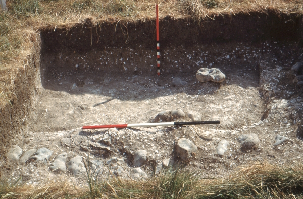
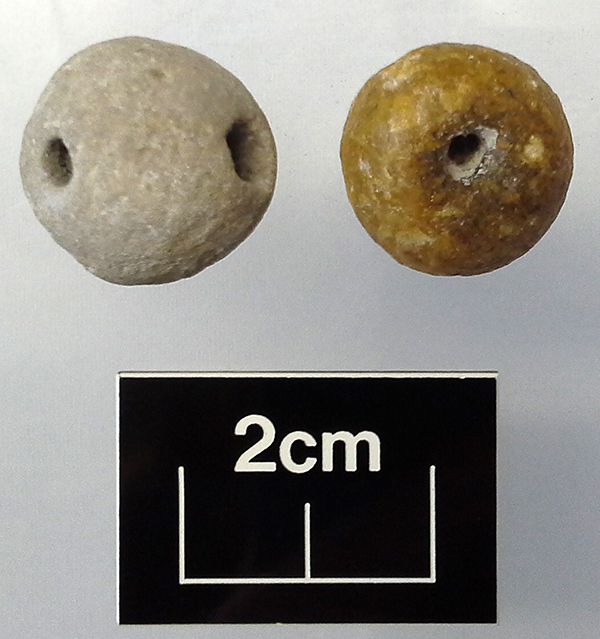
Today’s image for Day 300 of the VM_365 project shows two Late Iron Age/Roman beads from the box of archive from the 1964 Dumpton Gap excavation that we have been investigating. The beads have been made from materials that would have been readily available around the site, perhaps even picked from the nearby beach.

The bead on the right of the image is made from a light brown flint pebble that has been shaped to form a roughly round bead that has been flattened on each face. This bead appears to be unfinished; a large hole has been drilled partway through one side, while an attempt has been made to join the large hole with a much smaller hole on the other side but has not been completed. Other examples of unfinished objects found in archaeological excavations of a similar date nearby include a bone weaving comb and two spindle whorls.

The second bead on the left is made of chalk and is roughly spherical. Instead of having a hole pierced through the centre, it has been pierced off centre in a ‘V’ shape in a similar manner to the Beaker period jet button featured on Day 160 of the VM_365 project, to allow the bead to sit forward when strung on a cord and fastened around the neck.

Other VM_365 posts exploring the contents of this archive box have been posted on Day 293, Day 294, Day 295, Day 296, Day 297, Day 298 and Day 299.

VM_365 Day 299 Iron Age comb decorated sherds from Dumpton excavation archive

VM 299
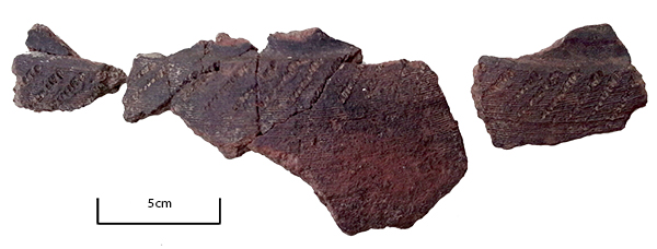
Today’s image, for Day 299 of the VM_365 project, shows six joining sherds and two other sherds from the decorated shoulder of the same Late Iron Age vessel. The sherds  belong to the pottery assemblage that we have been examining in our VM_365 posts, all contained in the the box of archive from the 1964 excavation at Broadstairs.

The sherds are from a large grog-tempered Late Iron Age ‘Belgic’ style storage jar, where a band of very fine horizontal combing has been applied beneath the plain neck and rim. In the upper part of the combed band there is a panel of diagonal decoration from the tip of the comb. This type of decoration, a narrowish band of diagonal or more commonly crossing diagonals of comb tip impressions, is quite a common occurrence on ‘Belgic’ style storage jars of Late Iron Age or Early Roman date. The sherds represent a vessel that probably dates to some time between 25-75 AD.

Other VM_365 posts exploring the contents of this archive box have been posted on Day 294, Day 295, Day 296, Day 297 and Day 298.

With thanks to Nigel Macpherson-Grant for kindly providing information on this vessel.

VM_365 Day 298 Iron Age pottery from the 1964 Dumpton Gap site

VM 298

Today’s image for Day 298 of the VM_365 project shows six sherds of pottery that were present in the box of archive from a 1964 excavation at Dumpton which represent a selection from the assemblage of three common examples of Iron Age pottery which are comparable to pottery found on other sites on Thanet.

The sherd of pottery on the left hand side of the image dates from the Early to Middle Iron Age and is an example of a sherd from a large coarseware rusticated jar. Pottery of a similar type and date has been excavated by the Trust from an Iron Age settlement site very close by in the mid 1990’s. The rusticated surface finish on the vessel represented by this sherd was deliberatley applied perhaps to provide an easy grip surface on a large vessel. Alternatively the decoration may have some symbolic meaning which was explored in the VM_365 Day 169 post on some Early to Mid Iron Age rusticated pottery sherds of similar type from Margate.

The three sherds in the centre of the image are all sherds from Late Iron Age comb decorated, globular bead rim jars. Comb decoration was a technique that was frequently used in the Late Iron Age period although it had been used earlier in the Iron Age and was explored in detail in the post for Day 223 of the VM_365 project. An example of a reconstructed jar from Margate of a similar type to these sherds was featured on Day 170 of the VM_365 project.

The two sherds on the right hand side of the image are also examples from comb decorated jars although these jars would only have been decorated to just below the rim in a similar manner to the jar from Hartsdown, Margate featured on Day 224 of the VM_365 project.


VM_365 Day 294 Iron Age and Roman pottery sherds from 1964 Dumpton excavation Archive

VM 294

The image for today’s post on Day 294 of the VM_365 project shows the contents of some of the paper bags, stored in an archive box from an excavation carried out by Joe Coy with the Thanet Excavation Group at Dumpton, between Broadstairs and Ramsgate in 1964.

To understand how important the information contained in the archive is, we need to carefully examine how and why each item has been stored and labelled. In the image above the sherds are laid out on the paper shop bags they were stored in so that they can be assessed in more detail. Later they will need to be catalogued and put into plastic bags which will help to ensure their safe storage in the long term

All but two of the bags in the 1964 excavation box contain pottery sherds. The sherds have generally been marked with a site code and feature number, which we now know corresponds with feature numbers on the sketch plan in the box.

There seems to be no corresponding finds list, description of the pottery or dating for the items in the archive box, so each pottery sherd  may have to be re-examined to understand the date range of the features fully.

However even a casual examination of the material reveals the span of the dates covered by the sherds, apparently a classic assemblage spanning the Late Iron Age and Early Roman period. Many of the pottery sherds are comparable with typical vessel types from other sites the local area, which have featured in earlier VM_365 posts.

The site excavated by Joe Coy and the Thanet Excavation Group in 1964 is very close to a large site excavated at Dumpton Gap by Howard Hurd, one of Thanet’s archaeological pioneers. Although Hurd emphasised the Iron Age aspects of his site, described by him as the remains of ‘a Late Celtic Village’, later excavations suggested that there was a more significant Roman element to the settlement than was previously thought. As we start to understand the 1964 archive, it looks likely that this will make a significant contribution to understanding that Roman settlement phase here.

The analysis will continue in subsequent posts.

VM_365 Day 286 Bronze Age Barrow, refurbished in the Late Bronze Age

VM 286
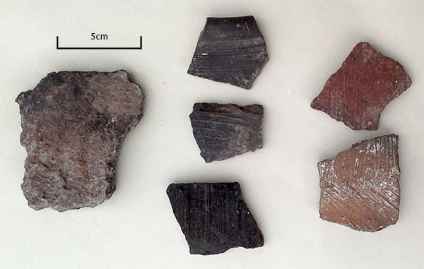
For Day 286 of the VM_365 project we have an image that shows another of the ring ditches of a Bronze Age barrow, excavated at St Stephen’s college, North Foreland in 1999.  The ring ditch was shown in an  overview of the site which was the image featured on Day 284 of the VM_365 project.

The picture on the left shows the barrow ditch under excavation, with a series of segments being excavated from the fill to show the layers of deposits in profile. The picture on the right shows the profile of one of the excavated segments  showing the sequence of multiple fills and interfaces in section, revealing that the circuit that was seen in the ground was in fact formed of two superimposed ditches cut at different times. The earlier ditch circuit had been at least partly filled in and had been refurbished by digging a new circuit around the same footprint.

The original ring ditch, measuring 18m in diameter, was probably cut in the late Neolithic/Early Bronze period, contemporary with a burial that was located at the centre.  The earlier ditch cut was slightly irregular, having been formed of a series of  straight segments in a similar manner to the ring ditch shown on Day 285. The profile measured approximately 1.5m wide and varied between 0.6 and 0.7m deep. The earlier ditch had been cut with a flat base, with steeply sloping sides angled at approximately 60°, part of this flat based profile can be seen in the right hand side of the picture of the section on the right.

The surviving fills of the primary cut which had not been removed by later activity  consisting of thin laminated bands of loam and chalk fragments, often with a fine graded appearance suggesting the erosion of the chalk barrow mound and edges of the ditch. It is likely that the earlier ditch had filled entirely before it was recut along the same circuit, probably in the late Bronze Age. This time the ditch cut had a steep V shaped profile, which cut away one side of the old circuit and penetrated the chalk below the flat floor as well.

The intersection of the two different cuttings can be seen most easily in the right hand image, by following the chalk in the cut from left to right. The steep side of the original ditch breaks to the platform of the original base, which then breaks sharply at a steep angle to the V shaped notch cut by the new circuit. The right hand side of the notch rises at the same angle along the inner edge of the new ditch cutting.

The later refurbishment of the barrow by cutting a broader ring ditch with a V shaped profile through the filled earlier ditch suggests the original barrow may only have existed as a raised earthwork rather than a ditch, although it may have been an impressive feature even after years of weathering.

Why was the ditch circuit recut on the same plan?

Two grave cuts were identified within the Barrow platform. Because of its regular placement in relation to the circumference of the ditch,  the central burial is likely to be associated with the original construction of the Barrow. It is possible that the other burial, which lay in a smaller oval cut,  may be associated with the refurbishment.

The newly cut ditch probably also remained a prominent landscape feature for centuries, its ditches still visible as deep hollows around the circuit. The  post for VM_365 Day 271 featured a bronze age barrow ditch that must have still been a substantial earthwork in the Roman period when large amounts of pottery were tipped in to its upper fills.

In the upper fills of the recut ring ditch at North Foreland pottery in transitional Late Bronze Age/Early Iron Age fabrics was found in relatively large quantities, along with small amounts of 6th century BC pottery contemporary with the earliest occupation features of the  Iron Age, suggesting that the final filling of the re cut barrow occurred early in the Iron Age when the hill top was being turned into a nucleated settlement, with enclosures and clusters of post built structures, served by a major trackway leading from the sea.


VM_365 Day 284 Excavation of a Prehistoric site at North Foreland, Broadstairs

VM 284

The image for Day 284 of the VM_365 project shows archaeological excavations in progress in 1999, at the site of St Stephen’s College, at North Foreland, Broadstairs. The view in this picture faces north west toward the mouth of the Thames Estuary, although the sea is hidden behind the range of trees at the top of the picture.

The  St Stephen’s College dig site is located just to the east of the cropmark group at North Foreland that was shown in yesterday’s image for VM_365 Day 283. One of the ditches that shows in the cropmark extended into the site.

The wide range of features found on the site are all represented in the picture. On the top, right hand side is the ring ditch of one of three Bronze Age round barrows excavated on the site. This barrow contained three burials, a large rectangular central grave cut and a second, smaller, oval grave cut on the northern side of the Barrow. A second burial had been inserted in the upper fill of that grave. The circuit of the barrow ditch had been recut in the Iron Age, possibly to form a hut platform.

On the left side of the picture you can see the ditches of an enclosure, dating to the Middle Iron Age. An  entrance causeway formed by a break in the ditch circuit can be seen at the front. Some of the ditches that branch to the top of the hill from the trackway that can be seen in the cropmarks on the hillside lead directly to the rectangular encloure.  At least six structures built with four timber posts were enclosed within the rounded rectangular ditch, although these could be from a different phase of the settlement when the ditch was no longer visible.

The group of storage pits visible in the foreground, close to the entrance of the enclosure, were dug over a period of time spanning the Middle to Late Iron Age.  One of the storage pits located in another part of the site, not shown in the image,  was reused for a burial which featured in a sequence of VM_365 posts on Day 123, Day 43 and Day 113. Iron Age objects found in some of the pits excavated on the St. Stephen’s site including Bridle bits, a bone handle, loom weights and evidence for chalk plastered structures have also been posted as part of the VM_365 project.

The tiny figure present in the middle of the enclosure is the Trust’s first Director Dr Dave Perkins who led the excavations in 1999.